Sumner Hill Historic District
The National Register of Historic Places is the nation's official list of cultural resources worthy of preservation. Authorized under the National Historic Preservation Act of 1966, the National Register is part of a national program to coordinate and support public and private efforts to identify, evaluate, and protect our historic and archeological resources. Properties listed in the Register include districts, sites, buildings, structures, and objects that are significant in American history, architecture, archeology, engineering, and culture. The National Park Service, part of the U.S. Department of the Interior, administers the National Register. The text below is excerpted from the registration form submitted to the National Park Service in 1987. Brian Pfeiffer, Architectural Conservation Trust; Carol Kennedy, Boston Landmarks Commission; and Nancy Friedberg, National Register Director, prepared the form. The nomination form is dated April 1985; revised June 1986.
The Sumner Hill Historic District is located in the Jamaica Plain Neighborhood of Boston, approximately seven miles southwest of the city center, in an area roughly bounded by Seaverns Avenue, Centre Street, South Street, Carolina Avenue, and the Southwest Corridor. The district, which encompasses 365 acres, contains 63 buildings and 18 structures, of which 28 buildings are designated as non-contributing due primarily to severe alteration, temporary nature, or recent age rather than intrusion. In the following description, the district's architectural development is described chronologically by style with selected buildings offered as outstanding and/or characteristic examples of particular styles.

The Sumner Hill Historic District is a well-preserved, wood frame, residential area developed throughout the latter half of the 19th century. In addition to domestic dwellings, the district features several distinguished stone and brick public buildings, including two churches and one school. Commercial intrusion isminimal, and is confined to one structure, a garage, located at the foot of Harris Avenue. Although several of the larger single-family houses and the vacant Jamaica Plain High School have been, or are in the process of being, converted to multi-family use, the district retains its single-family residential character.
The Sumner Hill Historic District occupies a portion of the hilly spine of Jamaica Plain that runs roughly north/south between Centre Street and the Stony Brook Valley (Southwest Corridor). Most of the district is steeply contoured and the upland area of the district, the product of the subdivision of several large 18th century estates, is characterized by picturesquely curving streets; generous, well-landscaped lots with puddingstone retaining walls; and large, architecturally distinguished homes. Many tall, handsome maple and beech trees are scattered throughout the area, and copious plantings and shrubbery add to the 19th century suburban atmosphere of Sumner Hill. No public open areas exist in the district with the exception of a few undeveloped house lots; however, the heavy plantings, deep setbacks, and meandering streets of the neighborhood create a park-like feeling that distinguishes the district from its surroundings.

The Sumner Hill Historic District consists of an outstanding variety of large single-family residences that were built between 1850 and 1900. The structures encompass a multitude of architectural styles including Italianate, Second Empire, Victorian Gothic, Stick, Queen Anne, Shingle, and Colonial Revival. Many of the structures were built by well-known Boston architects in the most fashionable styles of the day, and all structures exhibit a high level of workmanship and quality of materials. Most of the houses in the district use a wide assortment of materials in complex and inventive ways and are irregularly massed, contributing to the architectural vitality and depth of the district.
The Sumner Hill Historic District retains a distinctly different atmosphere from the areas immediately surrounding. Its clear residential character and narrow streets separate Sumner Hill visually from the commercial activity of Centre Street on the west. Historically, the Boston and Providence railroad bed (Southwest Corridor), constructed in 1834, has created an effective barrier from manufacturing activities of the Stony Brook valley on the east.
To the north and south, the difference in architectural quality, density, scale, and period of development separate Sumner Hill from other residential areas. The Sumner Hill area has maintained its architectural quality and has suffered very few losses or major alterations to its residential structures.
Alterations that have occurred have primarily involved the application of synthetic siding, the enclosure of porches, and small side and rear additions. Almost all of the houses in the district are well-maintained and several buildings on Sumner Hill are being restored or renovated. Except for the development of the Southwest Corridor, no known alterations have occurred that may have disturbed archaeological features in the district.

The earliest Italianate-style houses in the district were constructed on land subdivided in the 1850's from the David Greenough estate. The first house built on the newly created Elm, Alveston, and Roanoke Streets was the imposing General William Sumner House (10 Roanoke Avenue), 1852. The house, which dominates the crest of the hill, is distinctive architecturally for its transitional nature, combining a Greek Revival-style pedimented entry, Doric columns and corner boards with paired cornice brackets, hip roof, and long narrow windows typical of the Italianate-style. The nearby Gilbert House of 1854 (83 Elm Street, built two years later, fully embraces the Italianate-style and exhibits its characteristic cornice brackets, two story bay windows, hood mouldings, and paired round arched windows. The Italianate-style remained popular on Sumner Hill for the next 30 years, and numerous examples may be found throughout the district, including a well preserved group of ca. 1855 L- and T-plan houses on Harris Avenue (7, 9, 11, 15 Harris Avenue.)
Sumner Hill has several exceptional Second Empire houses, the most elaborate of which were built during the 1860s along the newly extended portion of Alveston Street between Roanoke and Greenough Avenues. The four houses at 20, 23, 28, and 31 Alveston Street are similar in plan and exhibit classic Second Empire details such as quoins, scalloped slate shingles, round-arched dormers, bellcast, convex and concave mansard roofs, and elaborate window mouldings. 23 Alveston Street, the most lavish of the four, also has incised Neo-Grec horal motifs and a two-story octagonal bay. Elegant Second Empire details also appear on more humble houses in the district such as the trio of slate-roofed mansard cottages at 84,88,90 Seaverns Avenue, ca. 1865. Brick mansard Second Empire rowhouses were very popular in more urban sections of Boston, but were an anomaly among the detached houses of Sumner Hill. 22-26 Greenough Avenue, ca. 1875, is one of only four such groups built in the District.

Development in the 1870s of Everett, Bishop, and Newbern Streets on the eastern edge of Sumner Hill produced several outstanding homes, four of which were the work of John D. Webster, a local builder and architect. Webster's distinctive homes, built sometime during the early 1870s, are eclectic and spirited combinations of Italianate, Second Empire, and Stick-style motif (9,13,15 Bishop Street.) The elegant house at 73 Elm Street, ca. 1875, with its jerkinhead roofs, stick work gable aprons, clapboards overlaid with vertical boards, polychromatic slate work, and asymmetrical massing, has been attributed to Webster, and represents the most elaborate Stick-style house on Sumner Hill. A "purer" example of the style also appears at 109 Segwick Street, 1872.
The Queen Anne-style is particularly well represented on Sumner Hill, and the area hosts some of the most architecturally sophisticated examples of the style. Large, well-detailed houses constructed in the mid-1880s, exhibiting complex plans, asymmetrical fenestration, elaborate porches, contrasting surface textures, and multiple chimneys, stand at 6, 8, 22 Everett Street, 11 Revere Street, and 11 Roanoke Avenue. 10 Revere Street, an exceptional example of the style designed by the well-known Boston firm of Ware and Van Brunt, is also responsible for Memorial Hall and the Episcopal Divinity School at Harvard University. This handsome house has an unusual roofline, vertical and horizontal boarding, turned porch posts, and a lively mix of shingles and clapboards. Other good examples of the style are located at 9 and 14 Newbern Street.
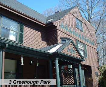
On the west side of the hill, the picturesque cul-de-sacs of Storey Place and Greenough Park provide intimate settings for a remarkable assemblage of Shingle-style houses, several of which were designed by William Ralph Emerson. These houses, particularly 9 Greenough Avenue, ca. 1880; 21 Greenough Avenue, ca. 1884; and 5 Greenough Park, 1893, exhibit a continuity of roof and wall and a continuously shingled exterior which expresses the structural frame beneath. Eyebrow dormers (21 Greenough Ave.) and swelling surfaces (15 Greenough Avenue) are characteristic elements of the style.
The Colonial Revival-style that began to appear in the 1890s was used throughout Sumner Hill as a design source for the last wave of construction in the district. John A. Andrew Street exhibits several simple, hipped roof homes typical of early suburban Colonial Revival houses (14, 24, 25 John A. Andrew Street). Much more sophisticated architecturally is 7 Greenough Avenue, 1893, designed by Clarence Blackall, well-known Boston theater architect, and George F. Newton. The house features an irregular combination of classical elements such as paired Corinthian columns, bowed entablature, and oval windows in an overscaled, asymmetrically massed plan. Located at the foot of Greenough Avenue, it provides an impressive introduction to Sumner Hill's collection of homes.
In addition to its many fine residential properties, the district contains several public buildings of outstanding architectural quality. These include two Gothic Revival churches, the Jamaica Plain Methodist Church (40 Elm Street), 1870, and St. John's Episcopal Church (Elm Street at Roanoke Avenue, 1882.) The Methodist church, which is perched on the slope of Sumner Hill, is a small, English, country-style, Gothic Revival building. Constructed out of native puddingstone, the steepleless church has pointed arch windows, a steeply pitched roof, and an octagonal apse.

St. John's Church, located further up Sumner Hill, is a more elaborate structure set well back from the street on the crest of the hill overlooking the Stony Brook valley. Designed by Harris M. Stephenson, an early proponent of the Colonial Revival-style, the church is constructed of Roxbury puddingstone with brownstone trim. It is composed of a square corner tower with pyramidal roof offset from a long nave, and has a late 1880s parish house addition. The church is in an excellent state of preservation except for poor spot repointing, and retains its typical Gothic Revival batten doors, tall pointed-arch windows, and polychromatic roof slates.
In 1834, the Boston and Providence railroad was established along the western edge of the Stony Brook valley, making the water power of Stony Brook more accessable, and industry developed rapidly in the 1840s and 1850s. The railroad also transformed the population of Jamaica Plain. Access to fast, efficient rail transportation meant that the populace was no longer limited to farmers and wealthy summer residents, and for the first time people could live outside of Boston and commute to work. In response to demands for suburban housing, many of the large estates In Jamaica Plain began subdividing the property for residential development.
In 1851, the western section of Roxbury, which included present-day Jamaica Plain, separated from Roxbury and was incorporated as the separate town of West Roxbury. Separate town status lasted only until 1873 when the citizens voted to annex themselves to the City of Boston. Shortly thereafter, in the 1880s and 1890s, a second wave of residential development occurred, with the establishment of streetcar lines that reinforced Jamaica Plain's link with the city proper. By the beginning of the twentieth century, residential development began to level off, and Jamaica Plain today retains much of its nineteenth century housing stock and remains a largely residential community.

The area encompassing the Sumner Hill Historic District, like the rest of Jamaica Plain, underwent two distinct phases of development. The first period began in 1850, when the heirs of David S. Greenough began subdivision of his "mansion house estate" whose boundaries encompassed most of the land in the district west of Elm Street, and lasted until the Depression of 1873. Development during this phase was largely a result of the increase in population brought on by the arrival of the Boston and Providence railroad. Estate land was sold in large chunks to resident speculators who built homes for themselves and further subdivided their lots.
A network of streets developed on Sumner Hill, reflecting its residential growth. In the 1840s, the only roads were Starr Street (Everett Street) and "Greenough's Street," but by 1850, Roanoke, Alveston, and Elm Streets were laid out on the crest of the hill. From the very beginning, the Sumner Hill National Register District was characterized by large-scale homes on generous lots, and succeeded in attracting upper middle-class merchants, businessmen, and professionals from both Jamaica Plain and Boston. The tone was established by the first house built in the district, the William Sumner House at 10 Roanoke Avenue in 1850. William Sumner (1780-1861) was a noted lawyer, legislator, and real estate developer whose extensive holdings included land in Jamaica Plain, East Boston, and Chelsea. Both the Sumner Tunnel in Boston and Sumner Hill were named in honor of General Sumner.

By 1858, extensions of Harris Avenue to Roanoke Avenue and Alveston Street to Greenough Avenue added new room for development. The three Italianate-style houses at 9, 11, 15 Harris Avenue, were built for Charles Brewer, a local merchant, on speculation and were typical of the type of subdevelopment that occurred in the district. The extended portion of Alveston Street was surveyed for house lots as early as 1859 and it is likely that parcels changed hands several times before construction occurred in the mid-1860s. At that time the street's large, well-preserved Second Empire houses were bought by a variety of professional people including insurance agents John Bumstead (20 A1veston Street) and Benjamin Putnam (28 Alveston Street); a retired Civil War colonel, F. B. Beaumont (23 Alveston Street) and a local grocer, David Keezer (31 Alveston Street.)
During the 1870s, commercial development adjacent to the Jamaica Plain depot at Woolsey Square (no longer extant) was paralleled by residential construction activity along Elm, Bishop, and Newbern Streets. In 1871, local architect John D. Webster purchased a five-parcel tract from George F. Woodman (83 Elm Street) and began constructing the distinctive Italianate/Stick-style houses that appear at 9,13,15 Bishop Street. To serve the spiritual needs of this developing section of Sumner Hill, the Jamaica Plain Methodist Church (40 Elm Street). 1870, was built at the intersection of Elm and Newbern Streets.
The Depression of 1873 slowed growth on Sumner Hill throughout the 1870s, and very few homes were built during this period. The notable exceptions are the four groups of brick mansard rowhouses (22-26 Greenough Street, 60-64 Elm Street, 26-30 Everett Street and 28-30 John A. Andrew Street, which were all built in the late 1870s. These atypical, multi-family units probably represent an attempt by speculators during this depressed period to maximize their investment by increasing the number of units per lot.
During the 1880s, Sumner Hill underwent a second wave of residential development. Boston's expanding population was rapidly outgrowing the confines of the narrow Shawmut peninsula, and nearby suburbs like Jamaica Plain became popular for residential expansion. The electrification of horse-drawn streetcars enabled trolley companies to expand their service, putting neighborhoods as far as ten miles from the city center within reach of the commuter. Sumner Hill's desirable location adjacent to the trolley lines on Centre Street helped maintain its popularity with upper middle class manufacturers and professionals, and fashionable new Shingle and Queen Anne-style homes were added to the district.
One of the earliest areas to be subdivided during this second phase was lower Greenough Street and Storey Lane. Several outstanding Shingle-style houses were built here in the early 1880s for corporate executives (2 Storey Place), Boston store owners (15 Greenough Street), and manufacturers (18 Greenough Street). At the same time, large, elegant Queen Anne houses were filling in the lots along Everett and Newbern Streets (6, 8, 22 Everett Street) and 11, 12, 14 Newbern Street, for a similar type of resident. Symbolizing the growth of the district, a second church, St. John's Episcopal Church (Roanoke Avenue and Elm Street), was built in 1882, on land donated by William Sumner. During the 1890s, available building sites on Sumner Hill became scarcer and development slowed.
Some of the last houses constructed on Sumner Hill were the Sturtevant-Foss House, (11 Revere Street), 1890; 7 Greenough Avenue, 1893; and the three houses built on tiny Greenough Park (3, 4, 5 Greenough Park), ca. 1893.
During the mid-twentieth century, the district experienced minor and reversible alterations as some of the larger, single-family houses such as 9 and 11 Revere Street were converted to apartment houses, nursing homes, and some lodging houses; many of the district's smaller houses have remained in use as single-family residences or have been modified as owner-occupied two-and three-family houses. In general, the physical changes made to buildings during this period were the enclosure of originally open porches, the installation of synthetic sidings, and the removal of some wooden ornamental details; however, the extent of these changes has been far less than in surrounding neighborhoods of Jamaica Plain which experienced extensive property abandonment. Within approximately the last five years, the physical decline of the district has been reversed by the rehabilitation and restoration of several prominently situated buildings.
Typical of this trend are the Victorian Gothic-style house at 73 Elm Street, which has remained an owner-occupied house throughout its history, and the Sturtevant-Foss House at 11 Revere Street, which has recently been restored as part of its conversion from a nursing home to residential condominiums. Similarly, the now vacant Jamaica Plain High School is scheduled to undergo exterior restoration as part of its conversion to residential apartments. Smaller-scale renovations throughout the district have tended to strengthen the area's late-nineteenth century character; a trend that seems likely to continue for the foreseeable future.
Sources
Boston Landmarks Commission. Jamaica Plain Project Completion Report, Part I.
Boston Landmarks Commission. Building Information Forms, Jamaica Plain Survey, 1983
Gilmore, Andrea M. "Sumner Hill", Alliance Letter, Volume 5, Number 5; June 1984
____________. Leading Businessmen of the Back Bay, South End, Boston Highlands, Jamaica Plain and Dorchester. Mercantile Publishing Co., Boston, 1888.
____________. "Data Pertaining to Streets in the Sumner Hill Historic District". Sumner Hill Association Historical Data, no date (manuscript Jamaica Plain Branch, Library).
Tucci, Douglas Shand. Built in Boston, Harvard University Press, Cambridge; 1978.
Warner, Sam Bass Jr.. Streetcar Suburbs: The Process of Growth in Boston, 1870-1900, Harvard University Press, Cambridge; 1962.
Zaitzevsky, Cynthia. "Victorian Jamaica Plain", Victorian Boston Today, New England Chapter, Victorian Society of America, 1975.
Boston, Brookline, Roxbury City Directories 1840-1915.
City of Boston, Building Permits.
Maps
Walling, Henry Francis. Map of the County of Norfolk, Jamaica Plain, Massachusetts. (New York: Smith & Bumstead, 1858 and 1866)
Atlases
Hopkins, Griffith Morgan. Atlas of the County of Suffolk, Massachusetts. (Philadelphia: G. M. Hopkins & Co., 1874)
Bromley, George Washington. Atlas of the City of Boston, West Roxbury, Massachusetts Volume 5. (Philadelphia: George W. Bromley & Co., 1884)
Bromley, George Washington. Atlas of the City of Boston, Boston Proper and Roxbury, Massachusetts. (Philadelphia: George W. Bromley & Co., 1890)
Bromley, George Washington. Atlas of City of Boston, Volume 6, West Roxbury, Massachusetts. Philadelphia: George W. Bromley & Co., 1896)
Bromley, George Washington. Atlas of the City of Boston, West Roxbury, Massachusetts. (Philadelphia: George W. Bromley & Co., 1914)
All photographs Copyright © 2003 by Charlie Rosenberg.