Jamaica Pond and Boston’s Water System
This article is based on a talk by Marcis Kempe, Executive Director of the Metropolitan Waterworks Museum, presented on December 7, 2014 at the Arnold Arboretum in Jamaica Plain. Mr. Kempe, an avid water-supply historian, discusses the early attempts by Boston residents to find drinking water on Shawmut peninsula. A system of wood pipes led eventually to the establishment in 1796 of Boston’s Jamaica Pond Aqueduct Corporation, which piped water directly to homes and businesses. In his talk Mr. Kempe chronicles this story and that of 1848 Boston’s municipal water system, which eventually replaced the Jamaica Pond Aqueduct Corporation system. Our thanks to Monica Salas for transcription and Kathy Griffin for editing.
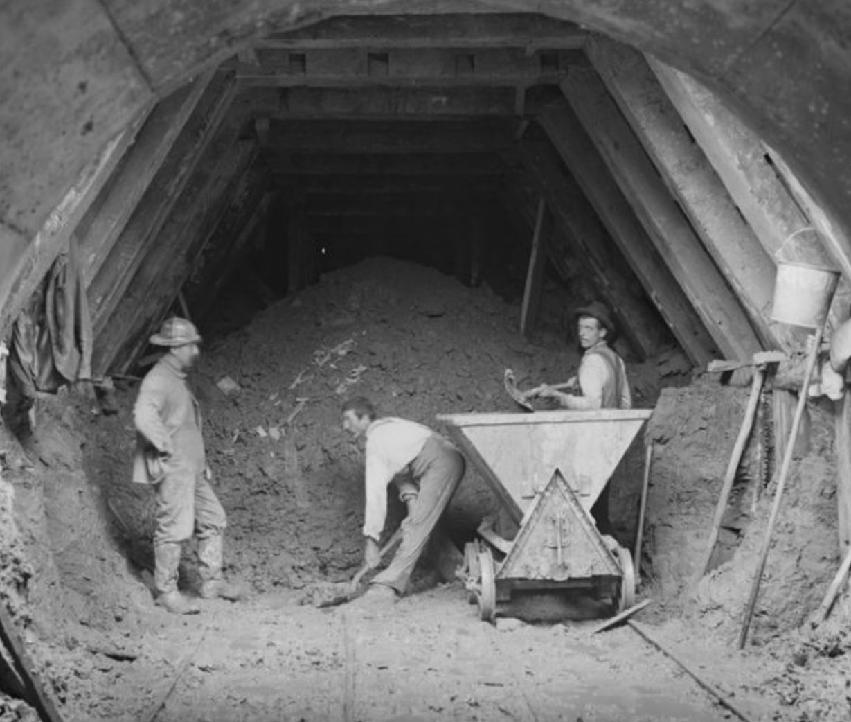
Weston Aqueduct, Section 2, west drift of Tunnel No. 1, near portal, Framingham, Mass., Sep. 22, 1902. Courtesy Digital Commonwealth. https://www.digitalcommonwealth.org/search/commonwealth:cv43p316w
A Powerpoint presentation that accompanies the lecture is available for download.
I want to thank the Jamaica Plain Historical Society and the Arboretum for this opportunity. I like getting out, and I like talking about water supply. This is what I’ve done for 37 years as my day job. My interest – I consider myself a water supply historian (laughter). I may be the only one that you guys know, but there will be others. There are some water historians nationally who write blogs and things and it’s pretty cool. I hooked up with the Waterworks Museum quite a while ago and I helped them sort of develop. They’ve been open to the public roughly three-and-a-half years, and I’ll do a little bit at the end that tells you something about it. By way of background, I’m an engineer. I studied water supply engineering. I realize I was a resident of Jamaica Plain at one point, too. My parents came off the boat from Latvia and I lived down by Egleston Square for a while. I drive past here every day on my way to work now, going over to my place at Chestnut Hill. So I’m the executive director, and former director. Today I wanted to talk about the history of Boston water and how it relates to Jamaica Plain. Obviously, there is a really important period involving Jamaica Pond, and I’ve come to understand that you’re interested in that, so let’s talk about that a little bit.
Starting in the beginning, the earth cooled … and the Massachusetts Bay Corporation came not as the first wave; the Pilgrims came first, and even before that Jamestown. The Pilgrims actually landed down in Plymouth area. One of the residents liked to be a solitary guy and he came up here to the Shawmut Peninsula and set up house here. William Blackstone – anyone hear that name before? A few. There’s actually a monument on the Boston Common of him shaking hands with Winthrop and welcoming the Mass Bay community in. But my point is – why? The Mass Bay Corporation landed – and they landed in Charlestown, which was populated by only a few people who came out of the old Cape Ann settlement earlier. They had bad water; they were getting sick drinking water from wells that were down in the area of present-day Bunker Hill Community College. This did not sit well with the Mass Bay Corporation; they didn’t want to stay there. So they got an offer from Mr. Blackstone to come to the Shawmut Peninsula. Shawmut is an Indian name that refers to something like “place of great waters,” because there was a great spring – and this was in a fairly attractive area to develop. Blackstone offered the site, and MBC took him up on it, so the reason Boston located itself where it did was to center itself around this spring. So right away we’re forming this population around water. It was protected by – when you are running a spring back then – people are running to the spring with buckets and carrying their buckets back home. And animals are running loose and kids and whatever, so they thought they needed to protect it, so they fenced it and put a cover over it and called it Spring Gate. In terms of this area, Spring Gate was located in present-day Spring Lane, off present-day Washington Street. George Washington was not a known figure in the 1600s. This is also near State Street, so you’re right in that downtown area. The monument is actually set on Spring Lane. If you know where the Old Corner Bookstore is, from the Old Corner Bookstore on the opposite side of the street there is a little alley way and that was Spring Lane. That was the center of the old community and literally you’d send your kids down to get a bucket full of water there. You didn’t wash much; you didn’t drink the water necessarily; you drank beer and wine which was safer. That is where it all begins.
The next big thing that comes along: industrious people who came from England, where they had certain prevailing technologies. One of the technologies was this invention from about 1400-something-or-other, fairly easy to understand: a wooden pipe. They understood the nature of the technology. You could set up a flow of water from a higher location if you laid your wooden pipe on a downhill slope. [Speaker passes around a piece of historic pipe that was unearthed by Boston Water and Sewer on Washington Street.] So the very first wooden pipe, the very first waterworks system actually comes about here in a place called the Conduit. The Conduit is in Dock Square area, very close to present-day Faneuil Hall. Several families get together and appeal to the local rich guy who has a modest stream behind his house, and they set it up so they pipe this down to their homes and they literally pipe it into their houses. So they have running plumbing in the year 1652. They have a terminal reservoir, which is shown in the woodcut picture here, which was drawn up by an artist from what texts were available. It is wrong on many counts, but it is a nice little picture that shows you the two main purposes for water back in the day. One was to drink and wash, and the second one was what’s going on in the background. All of the housing in the early years was wooden, including the chimneys. If you are familiar with a lovely reference work called Bronner’s Map of 1722 of Downtown Boston, it shows the location of all the great fires, and there were about a dozen of them. And that’s what they needed: a place where they could get water in buckets and put out fires. So this conduit was a great little operation for them. The drawing is wrong in the sense that the water comes in large here above ground – the artist wanted to visualize it, but this is New England, where we have a winter – just like modern piping, they would have been buried so they wouldn’t freeze. So you can be assured of water in the wintertime. So that is the first reservoir. It has all the elements of a classic water system. The Corporation, by the way, is studied by lawyers as it is the first active incorporation in the Commons.
I love this section by the way – it is in the lobby of my good friends in the New England Waterworks; they saved it from the early days. Every so often, you look inside and people have used it as a trash can.
If you were served by this system, you paid 12p a year to get your water. And someone had to mind it, so they took turns being the Warden. It comes out of an alleyway – if you look at present-day Faneuil Hall, near the Kevin White statue, there is a glass florist shop on the side of the Hall. That is roughly where the Conduit was. This is referred to in many texts as the first waterworks in America. [Editor’s Note: In 2018, the glass flower shop was replaced by a Sephora.]
When hunting around in the State Archives for something else, I come across this physical interpretation of Bronner’s map. I thought it was great that they thought enough of this to put the water features on the old map. You can’t find this map by the way – it is tucked away at the State Archives, and I found it by being in the back room.
Everyone in Boston doesn’t go to this spring all the time, or the Conduit. They realize that it is a shorter walk if you just dig your own well. What then happened was wells were developed by anyone with a shovel who could dig down to the water table. The other classic development was to try to collect the water off your roof into a cistern. This is in a day when you were burning wood and coal. You can imagine the quality of this water coming in. This is not what we enjoy today. What did happen is that you had certain famous (or notorious) wells. This is the one on the upper end of the State House, the Washington Street end, the opposite end of The Lion & Unicorn. Right where that drinking fountain is was the old town pump. This was a very famous place for a long time. The State House contains one drawn picture of the pump, there being no cameras back then to record it. It is a place where every traveler could come up and get a drink or fill a bucket as the city developed. What was going on downtown – you still had no idea about water quality; animals are still running loose; all transportation is by horses, and the sanitary situation is another story, too. All of these wells get developed in individual houses and you had a choice of building an outhouse or building a privy in your basement. In very many basements of buildings, you had what amounted to a cesspit. These would occasionally have to be mucked out. The guys called “nightmen” would come in and take the waste away. These wells and cesspits and privies are all right next to each other. And it all leeched through to the water table. Times were bad for sanitation. There were a lot of wells that were ruled undrinkable. And this is purely on aesthetics. If it smelled bad, you would have sense enough to not drink it.
This is what was leading up to the bringing in of fresh water from the suburbs. Now here we are in 1796. This is when the Jamaica Pond Aqueduct Corporation (originally called the Boston Aqueduct Corporation) was set up to make money, selling water to those that could afford it. If you were poor and couldn’t afford it, sorry – take your bucket down to the old well and get your water the hard way.
There were mills that were set up and had a long drill bit – they’d lay a pitch-pine log on to the table and push it onto the long drill bit, and get a fairly uniform pipe out of it. They were then assembled with a joint on the bottom. You can see (illustration) there is a piece of metal on the end – as it was wood you’d need a reinforcing ring around most joints, and even then you’d have trouble with the seals. They would cover them with pitch in an attempt to seal things up.
Let me point out a name here – Loammi Baldwin, Jr. is a giant of civil engineering. He’s not exactly a household name. His grandfather was an engineer during the Revolutionary War. Also a renaissance man, he invented the Baldwin apple. The father taught the son; the son taught his sons, and soon the Baldwins were building water supplies all over the place. They consulted to the Jamaica Pond Aqueduct Corporation.
Initially, Jamaica Pond, being a water source, and hence an energy source, attracted industry – a grist mill was a good solution and worked for a while – that runs up until the Corporation buys up the water rights. The pond is naturally collecting water; it has a watershed, not a very large one – but water would come into it. The pond is fairly deep, and is actually of excellent quality, due to the fact that it is a kettle hole pond that was formed by glacial action that punched a big hole in the earth. What it didn’t have was a lot of swamps or a lot of people around it to be discharging their waste, so in 1796 it is a great source of water.
I love the idea of the Corporation beginning at a meeting in a tavern. How many good decisions do you have that are fueled by beer? So these guys got together and got organized. Among them were some famous names in Boston: Loammi Baldwin and Charles Bulfinch. There wasn’t much above ground so Bulfinch didn’t have a major role, but Baldwin was a good surveyor who could ensure a long downhill slope, hence good pressure. And the engineer is usually responsible for the quality of construction and ensuring it was built properly. Why did they settle on Jamaica Pond? Not many other choices. Here’s Jamaica Pond, the first thing off the peninsula. In those days, Boston ended and then there was Roxbury. Jamaica Pond was a part of Roxbury. The first meaningful water source was here. And thank goodness it was a good one. I’ve seen a lot worse decisions; this is very nice. At sixty feet above sea level, it automatically limits you. Boston has a topography where some of the streets go up to ninety feet. So if you are living up on Beacon Hill, you’re out of luck. For feeding along Tremont Street, and where I have defined here (see illustration PPT slide 13), you could get certain things done. If you laid those pipes so they follow the Muddy River down, you get around Parker Hill and start picking up the area of Roxbury. That’s where their customers were. They got as far north as Massachusetts General Hospital – I think they literally supplied the hospital – and as far east as Fort Hill, before the hill got carved up and is now International Place area. The supply ran only to the bottom of Beacon Hill, and to just below the higher area – where the rich people were. So they were possibly sending their servants down with buckets to fetch water.
Financially, they thought it would be more of a shared arrangement, as they’d put out so many in price … turns out they were hard to sell, as not everyone was convinced that this was going to be a money-making prospect. So while they were expecting to pay dividends every year, they wound up going the first ten years without paying any. The value dropped and they did suffer, but water sales of course moved forward. After a while, it was the only place from which you could get clean water, so they did make their sales. They had pipes under the streets, and lateral pipes going into houses, mostly wood but occasionally if one had a sheet of lead you could roll it into a pipe and use that to pipe into the house. Of course, wooden pipes proved hard to manage. In the early days of water supply, there was a learning curve, like how deep you need to bury your pipes so the frost doesn’t get them. Frost will force everything apart. Nowadays, common practice is at least 4 feet deep. Back then they would have laid them a few times before they got them to a proper level.
And oh, by the way – there was a ton of waste. If you can imagine now, this modern convenience, where there is a tap in your home that will run all day long if you let it. You didn’t necessarily confine yourself to a glass now and then and you shut it off, what’s the harm? THERE’S NO METER. Until meters came along in water supply there was gross wastage by everybody. There actually was a whole discipline within the water supply community, of chasing people down and trying to figure out who is the one who is wasting, by going block-by-block and trying to determine if you heard water running. At its peak, you’d get to only 15-1600 houses so not the biggest system ever, but reasonably well-served. They had all these areas of reservoirs. And by reservoirs, it wouldn’t be anything as big as the room we’re in. They’d have pockets where since the pipes were kind of susceptible to interruption – if someone for instance broke a pipe, all the pressure from that point on was gone, and no one got service below there. So having some reservoirs beyond the break was a helpful thing. There was actually one on Fort Hill, where there was the biggest terminal reservoir. But they left a lot of them. And this was also due to the fire hazard we spoke of. At this time, Boston has already gone to brick construction, but all the existing houses are wood-framed.
Meters, by the way, didn’t get installed until they were affordable, which is in the early 1900s. People wasted water like crazy. Finally, with modern meters that stops. Leaks were found by guys with exceptional hearing who would literally drive a rod through the soil so they could hear the pipe. This is kind of what goes on today. I had a guy that used to work for me who was a leak specialist, who used to use geophones – which was like a group of stethoscopes connected. You would have sort of a drum set up where you would lie on the ground or you would touch a pipe where you could and you would put these things up to your ears like a stethoscope and listen – “is it my right ear more or my left ear?” – and figure out leaks that way. These guys with their skills could find things where we normal humans could not.
So how was service? It was not very good. With sixty foot of head available, by the time you get to the downtown area, at its best, that is twenty PSI of pressure at its best. And you lost a bunch of that on the way down. If it kind of oozed out of the pipe, you’re doing all right. It was still filling a bucket without having to walk somewhere.
They quickly found out your wood pipe isn’t a long-lasting material. Metal pipes like cast iron don’t come along until about 1820. The foundries in Pennsylvania finally got to the position where they could cast a reasonable iron pipe. There were some other odd, mongrel pipes where they would take a plate of raw iron and roll it, like a blacksmith would roll it and try to rivet it together. Not until cast-iron pipe did they have real success.
I did enjoy this picture especially [slide 16]; all of you who have gone to Home Depot know pipe fittings. They didn’t have common stuff like elbows and valves and things. That’s a water valve. If you wanted to stop water in a pipe, you saw-cut it a little and you drove what looked like a spatula down in there – that was your stop. If you wanted to open in again, you see it’s got a hole in it – put a lever in there and pull it open again.
There’s an urban legend that there are still wooden pipes connected. We’re running 80 PSI in the city, and it would pop instantly. They’re in the ground in some places, certainly. There were four long lines that were built down there, and once in a while there is an interesting harvest moment. Marty here is with Boston Water and Sewer and when the overhead was taken out of Washington Street, it limited construction underneath – you couldn’t put a lot of utilities there. So now that it is gone, everything is fair game and they open it up and boom – hundreds of feet of virgin wood piping. [Marty: “three hundred.”] Three hundred! The piece we were passing around earlier is from that. Some fun fittings there. That’s what the whole setup looked like. The reason for this big bend is – here’s Parker Hill – you had to go downhill by following the Muddy River. You laid your pipes that way and then you went back around. On Tremont Street and Washington Street they would run lateral mains off of that, then down at the very end up on Fort Hill was the terminal reservoir. Why? Because like every other water system, in case something goes wrong in the middle, you need some other water. Outages were frequent I’m sure.
The intake was over in the corner of Jamaica Pond by Perkins Street. This is a crude intake, and I am amazed it was only at a five-foot depth. Being at five-foot elevation is not a water supply ideal. There’s 50 feet of water there but you can’t get it because you’re only hooked up at the five foot level. In times of drought, they’d lose it. I love the mix and match on the pipe. We have some examples down at the office. Since you didn’t have store bought fittings, you made your own. You’d literally drill into the side of a log if you had to do a lateral connection. We have one in our lobby that has two big cap connections. It was tough to do these things.
Just to point this out, they had hydrants in the system – I think I mentioned hydrants – a hydrant was really just a fireplug. A fireplug meant there was a place they could go, where they kind of knew where the pipe was, and they would pull the piece of wood out that was shoved in there and that would allow water to bubble into a hole like a sump. And they would throw their pumps in there – you know the manual displacement pumps which were either pulled by horses or humans – and then humans would do the levering action to pump the water out. Then when you’re done, you drive the stopper back in.
That’s getting the original system into place. Now Boston continues to struggle. That only solves part of the problem. It gets the paying customers in the approaches to Boston, but not the tenements, for instance, in the North End. Just like Dickens in London, the tenements were kind of a tough area and there’s a lot more disease where the sanitation isn’t good. The medical community was especially pushing hard for water. They didn’t understand why exactly; they didn’t know it was all about bacteria; they just wanted to be able to wash the filth away – the filth that was on the streets and in the crowded areas. The guy who first took notice of all this and the first big advocate for water supplies was Josiah Quincy the Elder. Now there were a series of Quincys who come through the picture here. First Mayor of Boston, he made it one of his initiatives to do this. And he’s sort of the family connection – I really enjoy that this was sort of a father-son operation. In the incorporation days – in 1822 Boston incorporates and Josiah Quincy III – I don’t know how he comes before Junior, but he does – put people on the task. He assigned studies – “let’s go figure out how to do this for Boston, solve the problem.” And sanitary reform was valuable. He was a little bit ahead of his time because even England wasn’t pushing that hard in the early 1800s. Josiah Quincy Jr. happens to be the Mayor at the point of arrival. All the controversy is over and the time spent in between is arguing over how to do it, but he presided over the doing of it and the actual release of the water.
The controversy: I’m not going to go through all of this because it would take forever, but there were a series of options looked at. The first guy who was assigned by Josiah Quincy the Elder was a guy named Daniel Treadwell, who was a bright guy; I think he taught at Harvard at some point. He was an inventor. He had a lot of machines and patents. So he put a smart guy on it. There weren’t a lot of engineers. The only engineering that was taught was in the military, and that’s how Baldwin got his education. So he puts Treadwell on it. Treadwell looks around. Philadelphia had just started their lovely new water supply and they had – how many people have seen the Waterworks in Philadelphia? If you’re in Philadelphia, I recommend you go see the Waterworks. It’s a cool little museum. It’s right by the art museum. Anyway, Philadelphia had developed this lovely supply where they harnessed the river by putting it through a series of water wheels. The water wheels turned machinery pumps – displacement pumps – they pump the water up the hill and then it can flow down the river. And Treadwell thought – “Wow! That’s a great idea; I can do this in Boston. Let’s go out to where the river’s no longer tidal – let’s go to Watertown just above the low dam on the Charles River, and we’ll use that for energy and we’ll pump the water.” He had this weird vision: since cast-iron pipes were really rare, he decided he’d get some tree trunks and hollow them out and stick them in the river and that would suck the water. This was wrong on so many levels; it wasn’t a great idea.
The second set was – occasionally, there are stories that have shenanigans in them. Has anybody seen the movie Chinatown? A little bit about the L.A. water story. The engineering in L.A. was a wonderful water system built by Boston engineers. In the course of doing this great good for the public, there were politicians who wanted to make a profit on the deal. That’s kind of what happened with this middle one here. The idea of the use of Spot Pond and the Mystic Lake came up because there were some forces that had invested heavily in Spot Pond and some of the facilities up there, and stood to make a fortune. So they basically tried to steer the whole Boston process up there. It would be a little bit like Jamaica Pond, in that it was a very small pond, and once you ran out of capacity there, your only recourse was to drink from the Mystic River, and who in his right mind would want to do that? Strangely enough there were others who did do that. It was not a particularly good source. That was an entrepreneur proposal. In those days, Jamaica Pond was still an active entrepreneurial company. Boston Hydraulic Company wanted to be the same way, but on the north side and on a larger scale. The Middlesex Canal got involved because it is now losing business because the railroads are competing, and they’ve got this huge capacity to bring water down from above, from somewhere upstate, either Merrimack or in the Shawsheen River area. They were pitching themselves to Boston and saying, “We’ll supply you,” and that’s some of the worst water in the state once again. So thank goodness they didn’t listen to that one.
The guy most on the ball here is my friend Loammi Baldwin again. He proposed – and this is his sort of pipe route, which you can’t read obviously – he brought up the idea of “Let’s go west.” Urbanization around Boston was fouling every single river there was. The waste of everything … people first wanted the waste out of their house, then they wanted it out of their street, then into the river. And everyone thought there was this magic cleansing power of rivers. That it would all get better. But instead, they fouled everything in the urban area. If you went out beyond the urbanization, it made more sense. Now you could bring cleaner water in. He was proposing going to Farm Pond in Framingham as a solution. Better idea, still sort of half-developed. There was actually an involvement of (once again) Jamaica Pond. The Boston Hydraulic Company especially was looking for more resources. One of the hard things about being up in Farm Pond is you’ve got to cross major rivers to bring this down to Boston. In those days, bringing a pipeline across a major river was a big, big deal. So they were looking for ways to vent the pond on the south and expand service further. This was to tie into Lily Pond and tie into this stream here – and to get more watershed into the pond and make it more effective for supplying people. So this was going on and then you see my friend’s name here, Baldwin, and he was engineer extraordinaire for everyone, including the corporation. He was sort of their house engineer. In the end the problem was solved by bringing in a national expert, my friend Jon Jervis here. He was a giant in civil engineering. Giant in water supply, giant in railroads, you name it. He had just finished building the New York system. He had just built the Croton aqueduct, which was about 40 miles long from up the Hudson River – the Croton River up by Ossining. It was very unpolluted, and they built a nice dam there, built a long gravity aqueduct down to Manhattan, crossed with a beautiful bridge – all the things that were going to be necessary here were in that system. That starts in 1845. So he chose Long Pond with this.
This is what Boston actually built. This is the first municipal water supply. Municipal means, “We care about the poor. We care about everyone. We’re going to supply clean water to everyone that wants it.” So they actually raised the pond a little bit to make it a reservoir. It is oval shaped, almost like a sewer. It’s a brick construction, oval, cross-section conduit on a constant slope, going downhill at a very nominal rate, about 2 feet per mile. Some of the larger ones were a foot per mile. So you need very accurate surveying. It is a big engineering task. It comes down through here and dumps into some reservoirs. The first one built is Brookline Reservoir; Chestnut Hill comes later. At that point, you had cast-iron pipe available – technology advanced to the point where you could build without wood. And they were built out to satellite reservoirs which were just holding tanks in Beacon Hill, East Boston, South Boston – it was a place to hold water in case of fire. That was the old system in 1848. That is exactly what was built and the people rejoiced. They had attendance of around – sources say between 200k-300k people … Boston population at the time was under 100k. This meant that everyone from the suburbs came in to see this thing, because it was like nothing you’d ever seen before. There were parades all over town. This is one of the parade floats. There was a boat, and they built massive gateways across the street and towed people around. In the procession, they had a sense of humor; they put the politicians next to some con men. A good time was had; there were lots of speeches and things. Then the mayor goes, “Hey, do you want the water?” and he pulls something to start the flow and up goes the jet that you see here about 70 feet in the air. Lots of fun stuff. What a day. But let’s think about something. How many people here have swum in Lake Cochituate? Did you notice a certain earthy flavor out there? Everything is relative here. They looked at this water as the purest, the best. In real life, it was close to what it is today. Which is a long flat lake that is getting close to being eutrophic – it’s got a lot of organic material deposited in it over the years; it smells at times; there are algae blooms; there’s a lot of funky stuff that happens there, as they would come to find out actually operating the system. But this day, they celebrated. It was better than what they were used to, because they were drinking that stuff out of the local well and this was better.
Some of the facilities are still sort of around to see – this is out at Lake Cochituate – the old gatehouse. This is the crossing of the Charles River, which is very low, because they did it as a siphon. They brought pipes down and they did a low crossing to save money that would have been spent building big arches. There are these funky little gatehouses like this one – they were definitely afraid of fire so they literally had granite slabs on the roof. This is the old intermediate gatehouse at the old Chestnut Hill. Here’s the terminal of the Cochituate aqueduct, where it ends. This is Brookline Reservoir up by Route 9, which if you drive by it, is a lovely walking area. But it was the main supply to Boston; you can see Boston in the background. That’s the gatehouse where you take your aqueduct-delivered water through the pond, through some screens, into an intake pipe and down to the people. It was all pressure piping. And I did want to mention these little interesting reservoirs. These are gone but I like pointing them out because these are cool.
Beacon Hill was called that because there was a beacon on Beacon Hill. You hung a lantern on there and it was like a lighthouse. When you were looking for a site for a reservoir in Boston, the only site that was on higher ground was Beacon Hill, but they needed it at a certain elevation. They found a spot right behind the Old State House. And this is not the State House down by State Street; this is the real State House – before it was expanded. This is the Bulfinch design. So you needed a spot at about the right elevation there, so they had to carve out a piece of the hill. So this portion of the hill went to fill in a whole bunch of areas, like by the old mill and the Bulfinch Triangle areas, and that reshaped Beacon Hill. And this is what was produced. There was a book that Bulfinch did, a review of architecture of his day, where he was pointing out some of the best buildings in Boston, and he actually cited the Beacon Hill reservoir as one of the best buildings in Boston. You can see how this is rather closed off, but there are a whole bunch of archways here – you could literally ride your carriage into this thing – but it was a big pan of water held up by these columns of support – because it needed to fit in the location, but it is really an elevated tank. It did leak like a sieve, by the way. They didn’t have the technology to make it watertight. So – guess what they lined it with? Lead. Sheet lead, just what you want in your water supply. [Question from the audience about freezing.] It would develop a layer of ice that would go up and down on top with the flow of water of the day. Even modern water tanks have a layer of ice on top that goes up and down. Let me point out one thing on this structure. If you look carefully, you will see a granite plaque embedded in two corners. One corner had the engineers, one corner the politicians and the dates, very cool, and guess what – we found those about three years ago. I got a call from my friend Billy Foley over at Boston Water and Sewer – he said he found these weird plaques – you might want to come down and take a look. I had no idea of what to expect, so I went down and took one look – and those are the plaques that came off of the 1880 structure. The structure was demolished in 1880 because it was structurally inadequate. The City wanted the land, so it made sense for it to go.
In here, you see the mayor, the water commissioner, James Baldwin – one of the ever-present engineers. They’re all over the place. We saved these, held them and have now planted them outside of our doors. If you ever want to see a piece of the old 1888 Beacon Hill reservoir, it’s in our front door. These were actually out at the old pumping station at Columbia Point, because Boston had been using the site as a spoil pile. All excavations in Boston with somewhat dubious soil coming out, would go there to be stockpiled and eventually disposed. Often the far corner of the site is a bunch of blue tarps with junk all over them. And it wasn’t until Boston was withdrawing from the site – they were selling it to UMass who was going to develop it – when they were leaving, they were too good to throw away, but they didn’t have anything big enough to dig them up. So we at the MWA moved them and saved them, and displayed them the way they deserved to be. That’s what I wanted to point out to you. You guys have probably been to some of these sites here – the two reservoirs in South Boston and East Boston both had their little moments here. They were lovely construction. This one in South Boston (South Boston Heights) – you know the story of Evacuation Day – the cannons were brought to the Heights to force the British to leave – the Monument that was planted there was actually put in front of the water supply. There was a move to do this as part of the building of the reservoir at the site. So you have what looks like a church steeple sticking up here, that was eventually released again and that is now South Boston High School. High schools tend to grab the high ground. Same thing happened in East Boston; there was a lovely reservoir up there on Eagle Street, the one high spot in the main part of East Boston – and now it’s gone.
Back to the Jamaica Pond Aqueduct Corporation. Now that Boston has come in with a full municipal system – obviously if you’re JPAC, this is bad for business – it’s cutting you down a bit. They tried desperately during that long extended period, tried to improve their service, and actually started buying cast-iron pipes as the wood stuff was becoming problematic. You couldn’t deliver enough and the wood was breaking too often. They put their first ten-inch pipe in 1820 when they were first marketed, and wound up building a bit of cast-iron pipe. They tried to improve service by increasing efficiencies, dropping a few customers – in the end, Boston started paying them off to stop selling water inside of Boston, because we don’t want the competition. Boston didn’t want two companies opening roadways to fix pipes – so it made sense that they left. They still supplied Roxbury however. Roxbury at this point is still a separate community, and there are still a number of folks that are supplied. Not everybody – you can see that most people could get by on wells and local solutions. Those that are near enough to pipelines might have joined up. In the meantime, Boston took another look to see if there was anything useful here that they could save, and Boston gets to the period of rampant annexation of its neighbors. This is in the 1860s and 1870s, when Boston rapid-fire incorporated Dorchester, then Roxbury, then Brighton, then Charlestown – all those neighboring communities. And part of the sales pitch there was – “Look how well we’ve done on water supply for our community – we can do this for you. We will bring you water, we will serve you.” This was a major game-changer for Boston in the sense that it created this obligation – the politicians did this – they turned to the engineers and said, Okay, make it happen. It was a huge expansion necessary to get source water, to get infrastructure, to get pumping capability – all those areas were higher than downtown Boston, and they needed to be pumped. Thank goodness the technology had evolved to bring in steam pumps.
In the early days when West Roxbury and then Roxbury were incorporated, there was a division of how we were going to get water up there. The division of the water from the Sudbury River was still a ways off. There was a need for a temporary solution, and they were looking at Jamaica Pond possibly going westward and southward instead. If the pond wouldn’t supply downtown, then maybe it would supply with steam engines (Holly pumps). Maybe we can push water up the hill and supply Roxbury and those places. And they never got it together. They brought in Clemens Herschel – who did a whole slew of wonderful things in civil engineering, but locally the only thing he is known for is – you know the Public Gardens? There is a little suspension bridge across the pond. Guess who designed that suspension bridge? It’s a civil engineering landmark, designed by Clemens Herschel. They brought in some heavy-hitters to study all of this and looked at many options. At the same time they had been planning – when they annexed Roxbury they built a small pump station and they felt like – we’re already here, we’re in a better position – Jamaica Pond is nowhere near Brighton and some of the other sites, and it was smarter to stay with the core of the Boston system. So at this point, Jamaica Pond as a water supply entity is sort of wrapping up, when Boston came in and assumed Roxbury, then they started serving all the Roxbury customers. That’s just how it is with the municipal operation. So at that point, Jamaica Pond kind of goes away. So Boston grows up, and it develops the Cochituate Reservoir system to get larger. There was a massive construction project here at Chestnut Hill reservoir, a major project of the State. They had a moment where they had a break in the aqueduct, when there wasn’t enough water in the Boston end, so they had to build something bigger. This basin here still exists – this is over by Cleveland Circle. I’m sure you’ve all driven by it at some point. This was a creation of Boston’s before there was any pumping. It had two basins, and this is actually Boston College’s practice field now. They needed a second basin here because the Cochituate Aqueduct put out such funky water that at times it was undrinkable. They would literally divert it through a gatehouse into this holding basin and hold it while it cured itself, and brought it into another gatehouse at the bottom. When Lake Cochituate was finally tossed out, they wouldn’t need the back part and that’s when Boston College got the reservoir. That became a huge site. Just like Jamaica Pond, Chestnut Hill Reservoir is one of the recreational resources of the region. It was Boston’s park; it was on the end of a transportation line where people could come out, and that’s a Sunday afternoon and people enjoyed it. And this is the supply to Boston these days; it looks grander than some of the early stuff. There was once a fountain that came out there.
And here’s where we get to the real crux of the problem. Between Jamaica Plain, Roslindale, Hyde Park and West Roxbury, there’s a lot of high ground. This is sort of the background story of pumping in the urban area. In 1870, Boston had already made the annexation of Roxbury a priority. Roxbury had all that high ground – the Roxbury Highlands had to be served to fulfill the promise all the politicians made. We quickly rushed in to operations and built a little tiny pump station. And this is in the days of steam engines. I love the description of this building here: “A plain brick building without any architectural pretentions.” So if you’re an engineer, it’s sort of quick and dirty when you’re under pressure, and then there is doing it right at a later date. This was the quick and dirty. There was a local machine company – and these machines by the way turn out to be notoriously inefficient – like throwing money away, trying to boil water and push water around with those things. And it was a little teeny tiny rod. When I grew up in JP, and before I was an engineer I used to go by this and wonder what the hell is that? It was a water tower, the Roxbury Standpipe. This is pre-photographs, the planning stages of it (in the documents), that’s the historic picture, and that’s modern day. It is very well-kept by the neighborhood association. In fact, my friend Billy knows people in the Association and they have an occasional day of opening where they will have people up – you have inside of this thing a five-foot diameter standpipe. Literally a pipe that is stood on end that lets the water ride up and down; it’s a hydraulic control on the pumping. It’s part of the active water system, and there’s a circular stair that you could wind your way up there and come out the little door at the top, and get this amazing view of Boston. [Question: How tall is the pipe?] I’m not sure, at least fifty feet. And it was a wrought-iron riveted pipe, like you would do in the day. So that was the one storage vessel that serves the high surfaces. When they created the high service in Boston, it was to serve Roxbury Highlands, and oh, by the way – since Beacon Hill had struggled so much with the old gravity system, they dedicated a pipe to get over there and serve Beacon Hill. So the top of Beacon Hill became served by that stand pipe.
Guess what happened next? It was the Great Fire. Can you imagine? With a five-foot diameter tank, and that’s the only storage in the Boston area, VOOM! That thing is gone in the first couple of minutes. So that contributed greatly to the extent of the damage. 1872 is sort of a changing point. Like in most cities, Chicago had a great fire and New York had its own great fire. And then they learn from it and they build better. So, in this case building better was putting bigger pipes in the street and more storage. For Boston, that meant more storage. Instead of having that one dinky little standpipe, they built themselves a reservoir which was up on Parker Hill at the very top. Nice architecture. That was about 7 million gallons of water sitting up there and they used it to fight fires and things. That is now gone because it was too low again. Things get retired when they can’t do the job anymore. So this is now the site of the New England Baptist Hospital. So if you’re getting your knees done, this is where you go. The only Elmwood Pump Station, that little dinky station got all kinds of mechanical fixes that’s what pumps looked like in the day. You’d have a steam head that would push a piston back and forth and that would push a plunger back and forth and the bulbous looking thing is a surge arrester because all the violent back and forth would make the faucets pulsate if you didn’t put something in there to dampen it. Just like you do on a washing machine to stop the water hammering it. That was a modern steam pump. I threw this in here so you could see why they moved. Look at the circle and you can see all the belching chimneys and the pure congestion in there. They were definitely afraid that their waterworks was going to burn down because of some random fire in this area. So that was one of the kiss-of-death things, they needed to do a better pump station.
This is where they pumped to, by the way: there’s Roxbury standpipe and there’s Parker Hill reservoir above it. The same kind of thing happened in other parts of Boston. If you were in East Boston, they started developing the top of Orient Heights, and they had to build a pump station next to the reservoir, and it pumped up to this lovely tank. That was another one of those wrought-iron standpipes, in this case with a wooden façade with shingle. Guess what happened to that one? That burnt down. They never replaced it afterward – they brought in a high-service pipe. This is the height of irony, right? When you have water things burning down.
And this is what happened in your area. The high spots that were once fed by Elmwood were now being fed by this pump station. This is a pumping station up in Roslindale. If you went straight up Washington Street from Roslindale Square, like you’re going up to Bellevue Hill/West Roxbury Parkway – about three-quarters up the hill, this little pump station is right on the corner. This, by the way, shows the classic design of pump stations: there’s an engine room that has all of the big, interesting steam-pumping equipment inside of it, and then there’s a boiler room over in the side, and probably a coal pile out back. In this case, you would get coal from carts instead of trains. And one of these wooden staircases is built up on the top of Bellevue Hill. So that’s the original standpipe up there, and that had a lovely view, you could see all the way to the harbor from there. So they would allow public access to this thing, and you would walk up a circular staircase that would wind up and go to that. And this is the ultimate fate of that: there wasn’t enough water up there, so as demand grew, in 1913 there was another tank built up there that has, again, an internal tank, a metal tank with a circular stair. You could walk to the top up there and look around. And eventually – this is important and impressive – I went to a bunch of meetings in West Roxbury where people were raging mad at us to get that ugly thing off the hill.
That serves all the high areas. Most of you are getting water by gravity if you’re down around pond level to up to about 100-foot elevation of your house, and everything above that is being served by these tanks. This one was built over on Hyde Park Avenue near the Erie Pub. This was built as an old steam station with the classic design. You always see a chimney on the old steam stations because you were boiling water with coal and you needed to send the black smoke somewhere. In the back there was the boiler room and in the front here was the engine hall. In a more boring recent addition, in the 1950s, with diesel technology, you build pumps with diesel engines. And this one was in Brookline. It would drive the neighbors crazy because it would belch smoke – and we replaced it with modern electric motors, so now everyone’s happy and we have one little diesel generator there for backup.
That’s sort of the infrastructure. On the water-supply side, Boston had to instantly jump out to the Sudbury River to do this, and they built a whole slew of reservoirs. There is some lovely stuff that got done here and some heroic engineering and all that. This is one I wanted to point out, because this one – in order to connect the Sudbury River system, you had to build a very long aqueduct. This is the crossing of the Charles River done in a way that the Romans would be proud of. Water would be contained in that top pipe. You supported it with arches, so you wouldn’t have to build a massive wall. This is called Echo Bridge. This is down in the Hemlock Gorge area in Newton. If you haven’t seen it, this is actually an American Waterworks Historical Landmark, one of the few in our system. In my opinion, this has become the nicest example of a preserved aqueduct in the country. There are a few others around, but not a lot. New York had a nice one and they beat it up and tore it down. It’s gravity flow – inside of that space where the water is being carried – the water would only be about halfway up in there when it was fully operating, and that would move 90 million gallons a day to Chestnut Hill. One of the coolest things I found in the infancy of water supply – there’s an American Waterworks Association, and there’s a New England Association. The New England Association is going to host the American Association, and they want to do some fun stuff – some cool activities. One of the cool things they do is BOAT RIDES. Boat rides down that aqueduct. That’s about six miles there, all straight – it’s like riding the tunnel of love on a river. And you do that with a kerosene lamp in your hand, arrive at Chestnut Hill and climb up a ladder. How’s that for cool?
That’s the Sudbury Aqueduct. Some of the other facilities associated with it – some siphons and weird little structures, this is what they look like today, in modern times. You can see the graffiti starting to show up on that one – those Framingham punks – what can I say? I like the architecture of the old system. It was pretty well done, some nice features. These all still exist so you can go see these. This is modern-day Echo Bridge – you can see the arches there. It is especially lovely in the fall when all the leaves are starting to turn. This is another one like it in Wellesley, called the Waban Arches, across a fairly long, wide, flat area. And some of this architecture – there’s no purpose for that tower that I can tell, except maybe to wave a flag at the guy at the other end.
This is the terminal at Chestnut Hill Reservoir. This is the place that the people took the boat rides to. The other big thing that happened back in the day is that pump stations needed to be developed, so we have some fine examples of very old pump stations. This is the Chestnut Hill pumping station. Like I said before, Elmwood Street was the quick-and-dirty – this was the doing-it-right version. So they built this to be attractive, because in the late 1800s we were very competitive, as cities, with New York and Philadelphia and some of the others. And you want to take civic pride in some of the things you’ve built. So this was a statement that Boston’s water is excellent – it is a national example of how to do it properly. Something that doesn’t make a ton of sense – you see this tower here? You don’t need a tower in a pump station – it’s an architectural feature. My one guess by the way on functionality is – it served the reservoir on the next hill. That was about a mile away, and this is before there was any kind of telemetry possible. So I’m guessing that they put a tower on it, and they put a two-story gatehouse on the other end, in order for people to get out there with flags and say “I need some water!” Because otherwise you would have to ride your horse down to see what’s going on. So that’s what I think was going on. That’s what it looked like on the inside, coal bins, steam boilers and engines. This graphic is supposed to show you how a steam engine kind of works. This is how you did it. Back in the day, you would literally shovel coal into a boiler to produce steam. I actually showed this picture internally at a training function and I had a guy stand up and say, “Hey – you know that’s my grandfather, right?” That’s an example of steam engines back in the day.
This is what we do now. There is seriously a lot of engine worship that goes on in my museum. That’s our biggest exhibit; the old steam technology, because we have the advantage of never having had to tear out all the old steam engines to put modern equipment in. When our place stopped operating, it’s because modern practices had taken over, so all we had to do was shut down. So this is the steam engine. This one is five stories tall, so they’re impressive. This is the reservoir that we served.
When Boston had done itself a decent job, it was because they had more resources than most communities. Most communities had very poor local options and they made bad decisions. I hate to pick on Watertown, but Watertown was drinking from the Charles – downstream from the Waltham Mills. Which is not a great idea.
This graph is typhoid deaths. Look at the fact that there was an increasing line as urbanization put more pressure on – this problem just got worse. The Board of Public Health got involved, basically pushed for the formation of a Metropolitan District so everybody could have decent water – and this is what the district looked like. So now instead of being just Boston – it was built on the backbone of the Boston system – it goes south to places like Quincy, Milton, Hyde Park – and then north to all these communities and far-flung areas. That’s a difficult thing, and it required some more pump stations. We actually built a second pump station on the Chestnut Hill side, to push north, and lots of big stuff got built here. Our building got expanded, and one more engine got added. And oh, by the way, we laid pipes all over town. These were 48-inch pipes. And this was how it was done in the day: you put your pipe on a horse carriage, drove it to a job site, and guys with derby hats would put it in the ground. I especially love looking at this – do you notice? They’re wearing ties.
I got this great shot of somebody who was doing waterproofing for one of the water tanks and he’s up to his arms in tar – and he’s got a tie on. They did some amazing things crossing rivers and getting pipes into the ground. This is a great example of how you got it into the ground. It was just all chain pulls and brute strength, and OSHA looked the other way, and they build some interesting structures.
And then we went west for the water. Expansion to all those other communities – they’ve got about 20 new communities, and they needed a lot of water right away. The philosophy from the Boston system carried over. The idea was to go west where it was unpolluted. If you have good water to start with, you don’t have to go crazy treating it. So they built Wachusett Reservoir here, which was in its day the largest water-supply reservoir in the world. It has been eclipsed since by many. It was a big granite dam. They brought in Italian craftsmen to do the stonework, and that’s how they lived on the site for a while. That’s a granite masonry dam being put together there. This structure basically held back 65 billion gallons of water. In there was a bunch of hydroelectric turbines, and a tunnel went shooting out to the side. It is a lovely structure – the grounds here are used for things like wedding photos, and it’s a really pretty spot.
The Wachusett was connected by that. These are some of your giants of the day. Let me point out at least this guy. Remember that Chinatown story? He was one of the Boston engineers who went out there and built a 200-mile gravity supply to get water to LA. Regardless of who made money on it, the engineering was just amazing. These other guys are fairly famous as well. Stirrings was actually a consultant for the Panama Canal. That’s the kind of circles he ran in. So he brings his buddies along for a looksee… that’s Sterns in there. And you can feel them all going “harrumph” at the same time. One more back-story here, you’ve all heard of Quabbin Reservoir probably – that’s the next step. Sterns had actually called out Quabbin Reservoir as the next logical choice. Wachusett started suffering in the 1920s – and just like in the beginning of Boston, they spent about 10 to 15 years arguing about how to do this properly before they could actually build it. The controversy was all over the place. They looked at water supplies all over the state. Some people were suggesting places like the Ipswich or using some smaller rivers. What a mess. If we were to have built all that stuff, it would have been ridiculous.
The Quabbin was built; it was gravity flow; it was the right choice. But the actual building of it, this is where – most people are familiar with the stories of our system in the building of Quabbin, because this is one of the few places in the country where you literally had to move people out of the way to make way for a giant reservoir. There were four communities that were pushed out. The four were: Dana, Prescott, Greenwich and Enfield – and they were all sort of in this general area. They were literally dissolved and the borders of the adjoining towns moved in, and basically had a transition from the kind of simple country life to the stripping of the soil – when you make a reservoir, you basically have to muck everything out, or it is going to taste bad forever. So you take out all the swamps and things, all the structures have to come down. A few saved them and moved them somewhere else, otherwise they got broken down. A lot of sadness on the eve of the leaving; you had a sort of a last party. There’s a lot of sort of tear-jerking stories to the life there. If you had to be suddenly uprooted and moved because of this reservoir, you’d be pretty upset.
That’s the old valley with Enfield I believe, and that’s it prepared, and that’s it with the water. So this is an enormous story, if we had more time I’d talk about it more. So Quabbin was built with granite dams, with big earthen dams, and it is enormous. The sheer size of Quabbin is one of its best features. It took seven years to actually put the water back into it. If you look at the land character there – it’s basically forest. What happened there was all the land that was associated was taken, more so even than Wachusett because they needed to move people. One of the towns, the town of Prescott was actually up on a peninsula. It was above the water line – they could have stayed, but where was the surge going to go? They had to move them out so they could protect the reservoir. So by taking all of this we’ve removed any possibility of surge introduction of contaminants into here. Which is an enormous thing – you have no idea. It protects us against all the emerging contaminants out there. It’s like – I pick on these guys but – New Orleans drinks from the Mississippi after everybody in the country has had a go at it and left their own traces. You don’t want to be in that position because you’ll have emerging contaminants that somehow survive treatment and that’s a big problem. You don’t have that problem in our system. You guys enjoy some of the best water in the country because of the foresight of the guys that did this.
Here are some of my friends in the water treatment world. Here’s the John J. Carroll treatment plant. There’s Mr. John J. Carroll being taught how to run his treatment plant. He’s one of our oldest board members. Being taught by my whole management team, hopefully he didn’t do anything wrong. That’s our modern system. The sneaky hidden story is that, by Quabbin being created, it took the metropolitan system from being about twenty communities to what it is today, at about fifty. Because what wound up happening is it was a solution that was driven by public health – not by some crazed desire to upset some valley residents. No one wanted to be mean, but the supplies in the Boston area continued to be fouled. And we actually ran into waves of new foulings.
Remember in the 1970s with all the Love Canal stuff and pollution of water supplies? Do you recall the Woburn story with the leukemia? There were probably a half-a-dozen towns in our service area that lost wells because they were so contaminated, so they jumped onto Quabbin. So by building Quabbin you saved literally (annually) thousands of lives by producing excellent water quality and serving the people. And oh, by the way, it also happens to be very efficient. This gets us through the dark years. I actually started back at MDC in the day and we had no money for anything, and things got in horrible shape, but you know what? Gravity always works. So we were able to keep the system sustained by gravity flow, gravity treatment. Our water sits in this reservoir so long; it comes out of that reservoir as if it has been treated. It actually is better water quality.
So that’s where we are, I’ll stop there. I’d like to take questions, but I have one little film that talks about the museum. But let’s take some questions…[applause]
Q: When was Echo Bridge built and when was the “tunnel of love” ride?
A: 1878 on the construction, and I think it was in the mid-1880s that they did the boat ride. That was to show the rest of the country “wow, we’ve got cool things here.”
Q: When the reservoirs were first built, what did they look like and what was containing the water?
A: If you’re talking about source reservoirs – like Jamaica Pond is a natural depression, right? You would try to find an area that had sort of boundaries, that might have walls. In the case of Wachusett Reservoir, there a couple of natural rock formations that came together, making a sort of a simple dam a possibility, so they could build a wall across the valley and just kind of back the water up. That’s kind of the art of dam building; you would find the right topography that would support it. The same thing happened with Quabbin; they found that two dams were necessary, but they found a place in the valley that if you built a half-mile long wall of one sort, and another half-mile wall, that you could back up water 18 miles and make this enormous reservoir. In the smaller things, on the sort of hilltop reservoirs like you saw on some of those earth embankment reservoirs, you piled up earth and made it waterproof if you could.
Q: I heard a rumor once that Jamaica Pond is a backup water supply for Boston. Is that still true?
A: There is no physical connection. The only physical connections were wooden pipes. Frankly, you can’t do it. The only thing you can consider is in in a really serious fire, it’s a place where a fire truck could throw a hose, but not in any way to pipe it in. In fact, we take great pains to disconnect the unused, older sections so that there isn’t any possibility of anything that contributes a contaminant. So we’ve disconnected so many of our old reservoirs, cut and cap piping and that sort of thing. When it’s time, it’s time, and some of our old facilities turn into recreational facilities. Brookline is making a soccer field out of an old reservoir right now. And Newton is eyeing another one. It’s a good way to end the life.
Q: I have heard that Jamaica Pond water level is somehow connected to Boston Water and Sewer Commission’s system, and therefore they can add or subtract water at any time. Is that true?
A: I don’t think so. Any time you have a reservoir like that, what you try to do is divert drainage away from the pond because you don’t want street drainage to come in, because it is of lesser water quality. So most drainage is diverted away. I don’t think Boston Water has anything to do with management of the water level there. [another voice: “It’s spring-fed”] Right. The water that arrives there arrives because it has landed as rain and sort of percolated in. Most water supplies don’t tie into anything involved with outside drainage.
Q: Do you know what’s inside that pumping station in Brookline right now? Inside the building?
A: The gate house? That is actually another little project. Brookline is trying to restore that to be open to the public. What it was, was basically a screen chamber. One of my board members at the museum is actually one of the main driving forces. [another voice: “At one time it was a gun club”] Yeah. At one point it was handed over to be a sportsmen’s club – that’s the elegant version of “we like guns.” There was actually once a temporary pump station there, during World War II. They were worried – maybe we’ll need this again, if bombs drop on our pipes and we have to pump it. There was an old building outside that had pumps in it, that would transfer water from the reservoir up. The only thing that was inside there was some screening, and that has collapsed. And it will need a heck of a lot of work to get it back to anything. It will only be to walk inside the building and look at some unique features – it is one of the first iron-trussed roofs anywhere – my friend’s an architect so he likes this, but otherwise it’s an interesting building, but nothing ground-breaking. There’s no mechanical equipment.
Q: This is sort of a suburban anecdote. We were at the museum – the urban myth is there was a Curley welfare project to bring his boys out from Boston to give them a job.
A: That’s not a myth. Under the general heading of “shenanigans,” if you’re Curley and you have unemployed people… he was taking East Boston kids. We’ve got some movies that are literally playing on one of the DVD players, of guys being shown which end of the axe to hold. And being shown – you see that forest? Make it go away. That was a WPA-type work. There wasn’t actually much of that on Quabbin; the ratepayers actually paid for most of Quabbin. But that was the one thing, and that was sort of pushed into being by friends of Curley. [Audience member: “There was a lot of ill will because of it.”] Here’s another little trivia thing. There’s a point where the Quabbin aqueduct is almost called the Curley aqueduct. And then he got indicted on something else and whatever.
Q: Can you describe the buffer zone around the Quabbin and why is the Chestnut Hill Reservoir sometimes drawn down quite a bit?
A: The buffer zone around reservoirs is to ensure that structures don’t get built that may have the effect of polluting the water. So we didn’t want people building their homes there, because out there, home could mean septic tanks. Septic tanks could fail, so land was taken to prevent this, and they took land beyond the watershed boundaries just to make sure. Quabbin is the most aggressive. We still have a program at Wachusett where there’s a lot of land around the tributaries that has to be protected. We’re still trying to buy up parcels to make sure we can get it as tight as possible so there won’t be that.
Like most water bodies these days, Chestnut Hill has invasive species that come into it. We have Eurasian Milfoil growing in there. So one of the best techniques for trying to keep the crazy growth down is you drop it seasonally. If you can manage the elevation – you take the water out in late fall just before it’s going to freeze and you expose the plant roots so when it freezes, then boom. You control the plant growth. It is going to happen again this year, so watch for it. The elevation will go down six to seven feet below where it is right now. And we’ve been very successful doing this. The production of the invasive stuff is well-managed by doing this. So that’s what we’re doing; we’re not trying to do anything crazy. We almost got caught by the – you guys remember May 1st 2010, a day of infamy – the tunnel broke, and we were using the reservoir. And we were just in the cycle where we were filling the reservoir up and we had just gotten it up to the point where it was high enough to use the pumps effectively. Thank goodness for that – if it had been a little bit earlier. I managed that operation. That was a fun day in my life let me tell you.
Q: You had mentioned the Norembaga Reservoir? Where is that?
A: That’s out in Weston. And the Weston people prefer that you not know where that is. It was a distribution reservoir, so we’ve got it completely fenced. We don’t want people going in there and doing stupid things. In the 2000s, one of the great tasks for MWRA was to take any of the old open reservoirs and eliminate them, because there was just too much chance of polluting from atmospheric deposition or people throwing stuff in… in a post-9/11 world you don’t want your water supply exposed. So we build tankage everywhere, and there’s a big tank – if you’re driving on the Pike where you cross 128 heading west, up on the left you see my boss’s flagpoles – up there you see the water tank that replaced the Norembega Reservoir. It’s got enough water to feed the city for most of the day.
Q: With the building of the Quabbin Reservoir, taking away four towns was obviously a huge enterprise. One can also imagine that there would be unforeseen ecological effects over the years and what are some of those? What effects has such a massive change had on the overall ecology of the area?
A: It drastically changed everything. The land was in a state where it was a sort of hardscrabble farming area with cleared fields. Those fields grew back into forest. Most of the populated area was in the footprint of the reservoir, so that’s gone – covered by water. So from the character of the area, it went from looking very like the rest of central Massachusetts to being a very large reservoir – one of the authors called it the accidental wilderness. It looks like north Maine. With deer running around, it’s just a gorgeous park now. In a lot of ways, it changed for the better and it supports recreation better in this form.
Q: You talked about how much water was wasted in the early days in the 17th and 18th century. I was wondering what conservation technologies are you excited about both on the supply and demand side?
A: There were steps taken back then – 100% metering was the biggest step. Once people were paying for water, they were less likely to do stupid things. There was actually a period. When I started back in the ‘70s, we were running short of water. We were literally supplying water above our safe yield. Safe yield is a level you shouldn’t exceed because in a drought, you would run out. We were doing that during a period of time – thank god we didn’t hit a drought during that period of time – So we decided that there were options to develop new supplies, but the most important thing would be to try to get efficient. So we started a really aggressive water conservation program – I ran it back then. Where we targeted people in their houses, we literally installed devices in most of the households. Targeted commercial water use with best practices. The biggest and most effective short-term thing was fixing all the damn leaks. Most communities had been sloppy in their attention to how they were managing their systems. We paid for surveys – we found thirty million gallons a day of leakage in our first round of surveys. We took the system from being 340 million gallons a day, down quickly to about 280 million gallons a day. And the safe yield was 300. We did so good that we disbanded the group and moved on to operations and did other stuff. One of the most far-reaching things we did was get into the plumbing code and ensure that low-flush toilets were required – there were a whole slew of techniques and the effect of which – you know the Boston Harbor story – the dirtiest harbor in America? It took about two billion dollars to fix that. How does that get billed? With the huge number being billed back to customers, your water and sewer rate climbs and you become more concerned about water conservation because you’re costing yourself money if you’re being stupid. So people’s replacement of their devices took off, and we’re now at the point where we’re using 200 million gallons a day, two-thirds of our capacity. So we can take on customers. The recent development has been – some communities are in stressed basins that are around our periphery here. For instance, you’re in a town that is in the Ipswich Basin with a stream that literally runs dry in the summertime. The State policy-making people are saying that we should actually steer them toward the metropolitan system, that we should supply them during dry times at least, so the rivers don’t get stressed and kill fish. There’s sort of a new look at how water gets shared and we’re in a better position than ever to offer assistance to towns that are getting stressed out. There are a few on the edge of asking for admission, and a few that have come in in the last couple of years. There’s plenty of water to share, and actually doing everyone some good because we’re spreading the cost further. I think it has gone in a very positive direction. There was a point where no one wanted to see anyone come on to the metropolitan system, now we’re accepting new towns – I wouldn’t call it an open door because it is very expensive to get in and that is because we have to protect the investment of people that are already here.
