Historic Maps of Jamaica Plain
These maps were produced primarily for the fire insurance industry. They show building footprints and detail such as building material, function, owner, driveways, and street address. Also shown are lot lines, street widths, pipes, railroad lines, and bodies of water. Sanborn, Hopkins, Bromley, Phoenix, and other companies produced fire Insurance maps. The earliest fire insurance map of Boston appeared in 1867.
You can overlay historic maps within the Leventhal Map Center collections over a current location using their Atlascope tool. This allows you to see how streets and boundaries may have changed over time.
Maps Hosted on Digital Commonwealth
1896 George. W. Bromley, West Roxbury
1905 George. W. Bromley, West Roxbury
1906 George W. Bromley, West Roxbury
1915 George W. Bromley, West Roxbury
1924 George. W. Bromley, West Roxbury
1884 George. W. Bromley, Roxbury
1890 George. W. Bromley, Roxbury
Maps available from the State Library of Massachusetts:
1884 G.W. Bromley Map of West Roxbury at State Library of Massachusetts Link 22Mb PDF
1891 Bird's Eye View of Jamaica Plain View 1891 map
1905 G.W. Bromley Map of West Roxbury at State Library of Massachusetts Link 87Mb PDF
1914 G.W. Bromley Map at State Library of Massachusetts Link 95Mb PDF
1924 G.W. Bromley Map of West Roxbury, State Library of Massachusetts link 105mb PDF
The 1858 map is an inset from a map of Suffolk County and appears here courtesy of the Boston Public Library.
View 1858 map
1874 Hopkins Map of West Roxbury Photographed by Jamaica Plain Historical Society at City of Boston Archives
Cover page
Plate A
Arcadia Street / Atherton Street / Baker Street / Beethoven Street / Bismarck Street / Boylston Avenue / Boylston Street / Brookside Avenue / Cedar Avenue / Chapel Street / Chemical Avenue / Chestnut Street / Clark Court / Curtis Lane / Germania Avenue / Green Street / Jess Street / Lamartine Court / Lamartine Place / Lamartine Street / Oak Place / Porter Street / School Street / Washington Street /
A Street / B Street / Boylston Street / C Street / Centre Street / Chestnut Street / Curtis Street / D Street / E Street / Green Street / Sheridan Avenue / Spring Park Avenue / Terrace Avenue
Alveston Street /Carolina Avenue / Centre Street / Child Street / Elm Street / Green Street / Greenough Avenue / Gordon Street / Harris Avenue / John A. Andrew Street / Keyes Street / Lee Street / Newbern Street /Revere Street / Roanoke Avenue / Seaverns Avenue /South Street / Starr Lane / Union Avenue / Walker Street / Washington Street / Williams Street
Brewer Street / Burroughs Street / Centre Street / Eliot Street / Jamaica Street / Monument Street / Moreland Place / Myrtle Street / Orchard Street / Pond Street / South Street / Thomas Street / White Avenue
Centre Street / Chestnut Street / Lakeville Avenue / May Street / Orchard Street / Perkins Street / Pond Street / Prince Street / Rockwood Street
Autumn Street / Blue Hill Avenue / Calder Street / Canterbury Street / Chauncy Place / Egleston Square / Forest Hills Street / Glen Road / Greenwood Avenue / Lotus Street / Scarborough Street / School Street / Seaver Street / Walnut Avenue / Washington Street / Williams Street / Woodside Avenue
Canterbury Street / Ellicott Street / Forest Hills Avenue / Forest Hills Street / Lotus Street /Morton Street / Scarborough Street / Union Terrace / Walk Hill Street / Walnut Street / Washington Street / Williams Street
Albion Street / Ashland Street / Berry Street / Bourne Street / Brown Avenue / Canterbury Street / Florence Street / Folsom Street / Garden Street / Hyde Park Avenue / Mount Hope Avenue / Neponset Avenue / Pine Street / Prospect Street / Rowe Street / South Street / Spruce Street / Walk Hill Avenue / Washington Street / Weber Street
Allandale Street / Centre Street / Keyes Street / Pond Street / South Street / Washington Street
1884 G.W. Bromley Maps Scanned from Jamaica Plain Historical Society Archives
The scanned images below were taken from a 1884 G.W. Bromley Atlas graciously donated to the Jamaica Plain Historical Society by the estate of Margaret Durfee Mosher. We are grateful to Tom Blake for doing the high resolution scanning work. Production assistance with the street index was kindly provided by Kathleen Hourihan, Jeanette Murphy, Valerie Uber, Laura Kandziolka, Virginia Pittsley, Jan Paulsen, and Paul Walsh. These map files can be downloaded unlike some of the others shown here and are particularly high in quality.
Plate A
Amory St. Arcadia St. Atherton Pl. Atherton St. Beethoven St. Bowe St. Boylston Pl. Boylston St. Bragdon St. Brunswick Av. Centre St. Chestnut Av. Copley St. Danforth St. Dimock St. Forbes St. Gilbert St. Hoffman St. Houghton Pl. Lamartine St. Notre Dame St. Parker Ct. Paul Gore St. Raymond St. Roys St. School St. Sheridan St. Terrace Av. W. Walnut Pk. Washington St. Wise St. Wyman Pl. Wyman St.
Plate B
Alden Pl. Bismarck St. Boylston Ave. Boylston St. Brookside Ave. Brookside Ave. Byron Ct. Call St. Chauncy Pl. Chemical Ave. Ellsworth Pl. Erie Pl. Forest Hills St. Garfield Ave. Germania St. Glenn Rd. Green St. Greenwood Ave. Jess St. Porter St. Robeson St. School St. School St. Pl. Seaver St. Sigourney St. Union Ave. Walnut Ave. Washington St. Watson Pl. Weld Ave. Williams St. Woodside Ave.
Plate C
A St. Alfred St. Alveston St. Bishop St. Boylston St. Brewer St. Brown Pl. Burr St. Burroughs St. C St. Call St. Carolina Av. Cedar Av. Centre Pl. Centre St. Cheshire St. Chestnut Av. Chestnut Pl. Chestnut Sq. Child St. Clark Ct. Eliot St. Elm St. Enfield St. Everett St. Gordon St. Green St. Greenough Ave. Hagar St. Harris Av. Hathaway St. Hazel St. Holbrook St. J.A. Andrew St. Keyes St. Lamartine Ct. Lamartine Pl. Lamartine St. Larmartine Sq. Lee St. Lester Pl. Maple Pl. Myrtle St. Nelson St. Newbern St. Oakdale St. Park Pl. Pond St. Revere St. Roanoke Av. Rockview St. Seaverns Av. Sedgwick St. South St. Spring La. Spring Park Av. St. Johns St. Starr La. Story Pl. Thomas St. Walker St.
Plate D
Burroughs St. Centre St. Chestnut St. Eliot St. Holbrook St. Lakeville Place May St. Moreland Place Myrtle St. Orchard St. Perkins St. Pond St. Prince St. Rockwood St.
Plate E
Allandale St. Avon St. Bussey St. Centre St. Fairview St. Green Hill Av. Louders La. May St. Mozart Av. Pond St. Rockwood St. Skinner St. South St. Union Av. Walter St. Weld St.
Plate F
Custer St. Forest Hills Ave. Forest Hills St. Hall St. Hathaway St. Hyde Park Ave. Jamaica St. Keyes St. Lee St. Lotus Ave. Lotus Pl. Lotus St. Morton St. Park Pl. South St. Union Terrace Walk Hill St. Washington St. Water St. Williams St. Woodman St.
Plate G
Blakemore St. Bourne St. Brook St. Brown Ave. Florence St. Garden St. Hancock St. Hyde Park Ave. Larch Pl. Pine St. Prospect (Roslin) Ave. South St. Sycamore (Albion) St. Walk Hill Ave. Washington St.
Plate H
Austin St. Autumn St. Back St. Blue Hill Av. Calder St. Canterbury St. Ellicot St. Forest Hills St. Glen Rd. Morton St. Scarborough St. Seaver St. Sigourney St. Walk Hill St. Walnut Av. Williams St.
Plate I
Allen St. Ashland St. Berry St. Blakemore St. Bourne St. Bradstreet Av. Bridge St. Brook St. Brown Av. Canterbury St. Florence St. Folsom St. Hyde Park Av. Lawn St. Mt. Hope Av. Neponset Av. Newbern Av. Paine St. Peters St. Rowe St. Spruce St. Walk Hill St. Weber St.
Plate J
Albion St. Ashland St. Ashland St. Augustus Ave. Beech St. Brown Ave. Canterbury St. Charles St. Clarendon Ave. Clarendon Ave. Clarendon Park Clifford St. Crew Ave. Cross St. Dale St. Eldredge St. Farrington St. Hancock St. Hautevale St. Hillburn St. Hillside Ave. Huntington Ave. Hyde Park Ave. James St. Kittredge St. Mansur St. Metropolitan Ave. Newbern Ave. Perkins St. Poplar St. Prospect Ave. Richardson St. Rockland St. Roslin Ave. Roslin Ave. Rowe St. Sharon St. Sheldon St. Summit St. Sycamore St.
Plate K
Albano St. Alder St. Amherst (Cottage) St. Ashland St. Atherton Ave. Auburn St. Beech St. Bellevue Ave. Berry St. Birch (Maple) St. Brandon (Williams) St. Brook St. Cedar St. Central Ave. Clifton St. Corinth St. Cottage St. Cypress Dedham Branch Dudley Ave. Farrington St. Florence St. Hawthorne St. Hemlock St. Hill St. Kittredge St. Linden St. Metropolitan Ave. Mozart Ave. Norfolk St. Orange St. Poplar St. Rail Rd. Rockland St. Roslindale Ave. Salem St. South St. Sycamore St. Taft Ct. Taft Pl Union Ave. Walter St. Washington St. West St.
Plate L
Adelaide Terr. Bellevue Pk. Bellevue St. Centre St. German St. Grove St. High St. Lagrange St. Lark St. Martin St. Park St. Robin St. Rockland St. Short St. Washington St. Wren St.
Plate M
Allen St. Anawan St. Beech St. Bellevue St. Centre St. Clement Ave. Corey St. Farrington Ave. Garden St. Garfield Ave. Hildreth Ave. Irving St. LaGrange St. Linnet St. Maple St. March Ave. Martin St. Mt. Vernon St. Oak St. Oriole St. Park St. Pelton St. Pleasant St. Rail Road Ave. Rutledge St. Short St. Walnut Ave. Weld St. Willow St. Wren St.
Plate N
Alaric St. Ashland St. Autumn St. Baker St. Ballinakill Ave. Cass St. Centre St. Cottage Pl. Dent St. Elm St. Gardner St. Hart St. Ivory St. Jordan St. LaGrange St. Marshall St. Perham St. Pleasant St. Powell St. Prospect St. Spring St. Springville Ave. Summer St. Temple St. Winslow St.
Plate O
Baker Pl. Baker St. Belle Ave. Centre St. Charles St. Clarence St. Cypress St. Franklin Ave. Gardner St. Hamilton St. Linden St. Montgomery St. Moreland St. Pleasant St. Prospect St. Spring St. Walnut St. Washington Ave. Webster St.
Adams St. Baker St. Corey St. Dent St. East St. Gardner St. Garfield St. High St. LaGrange St. Morrison St. Mt. Vernon St. Perham St. Temple St. Weld St. West St.
Plate Q
Anawan Av. Arnold St. Beech St. Central St. Centre St. Church St. South St. Weld St. Willow St.
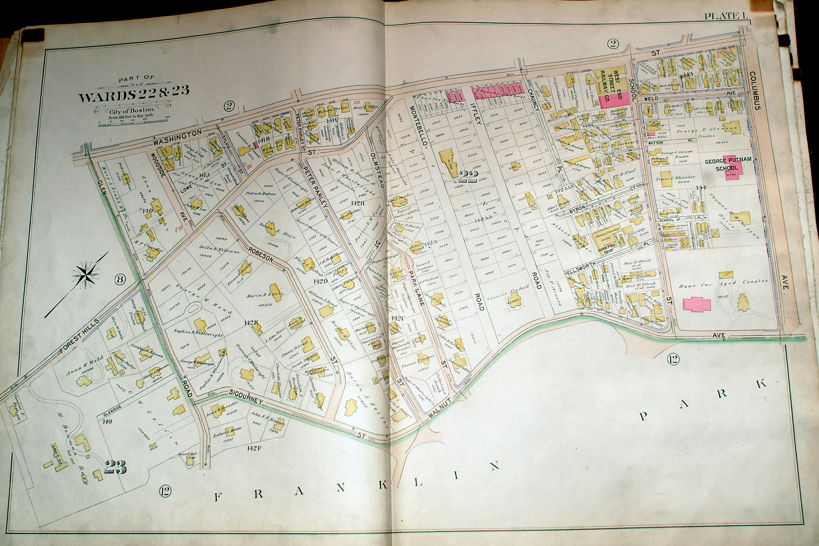
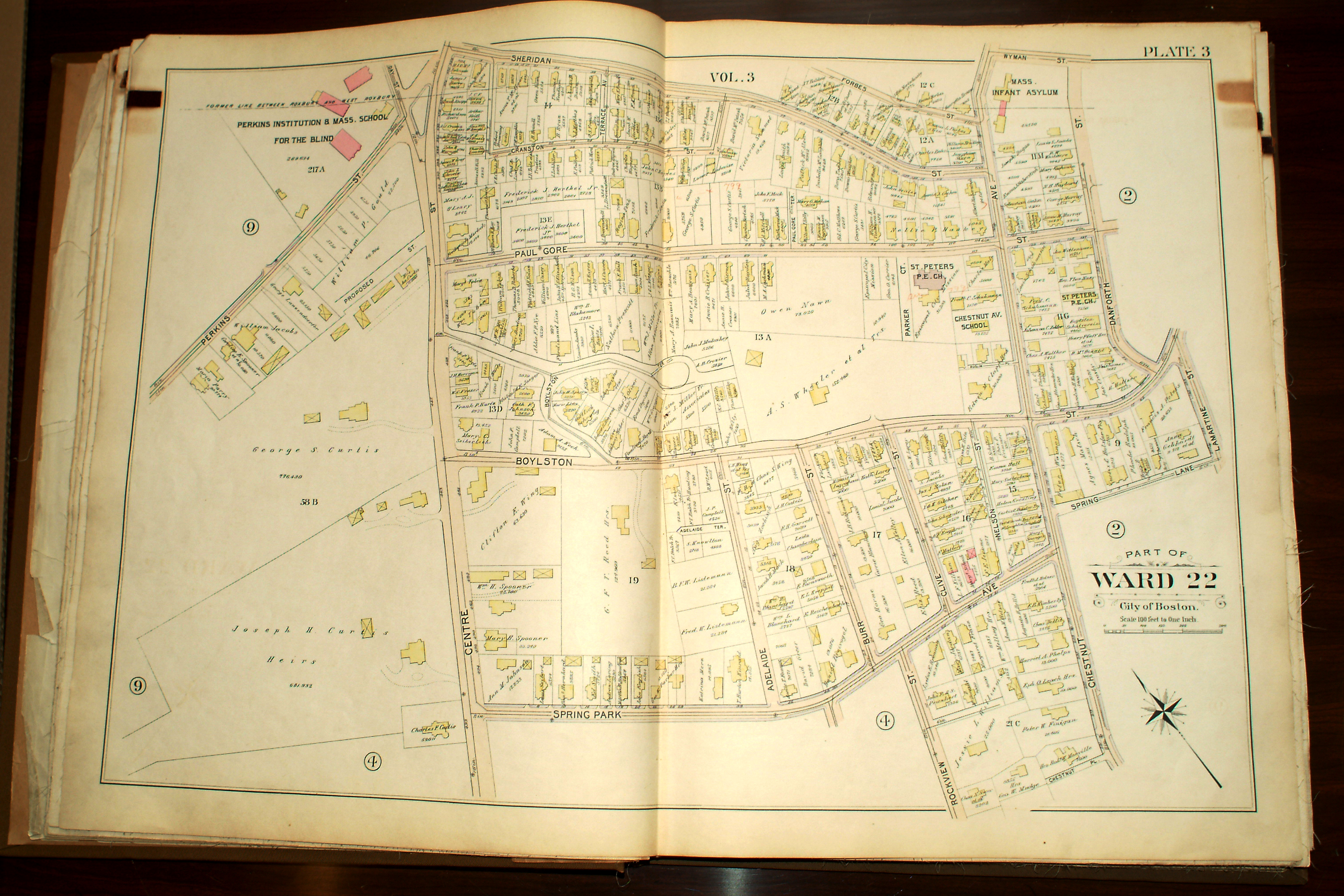
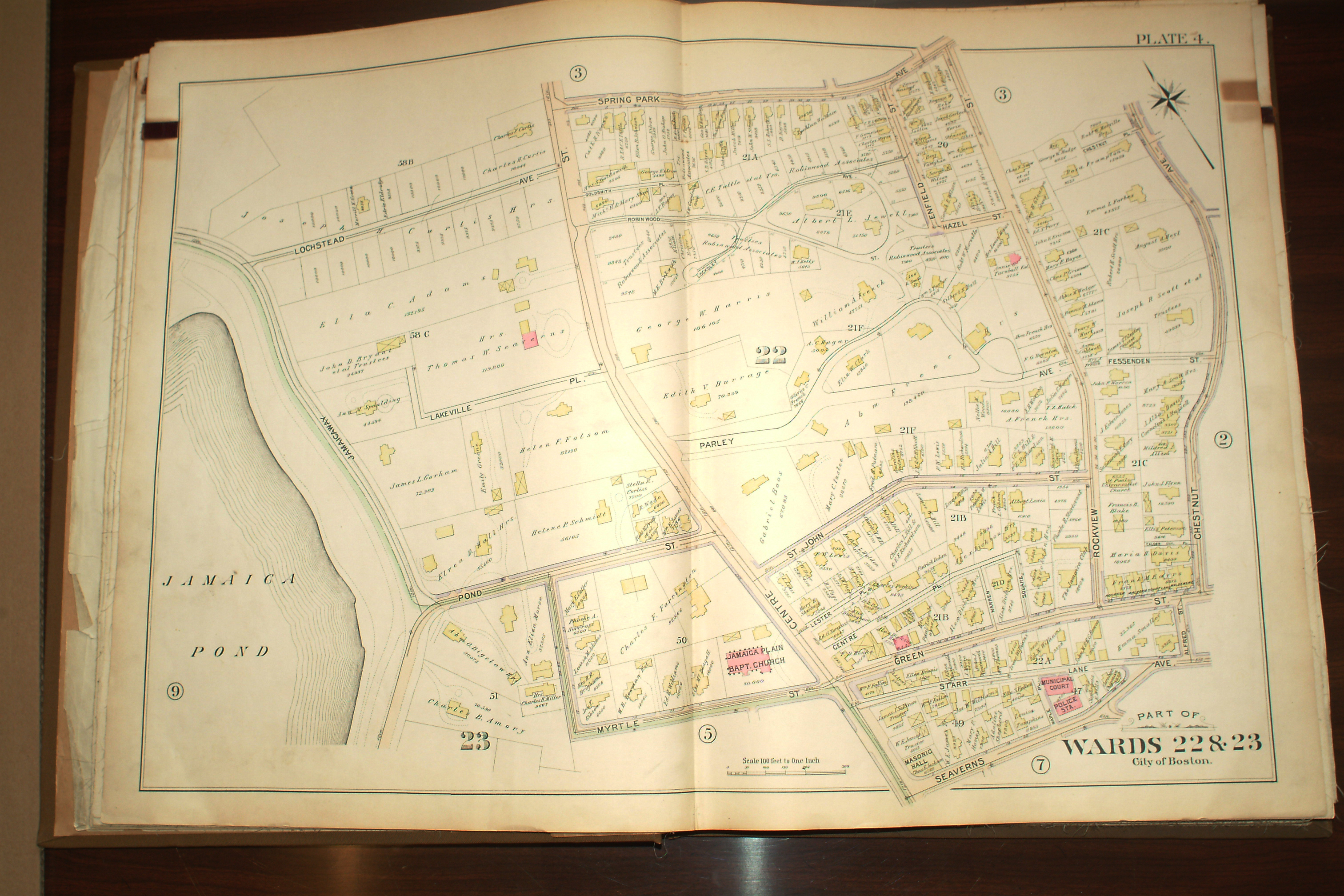
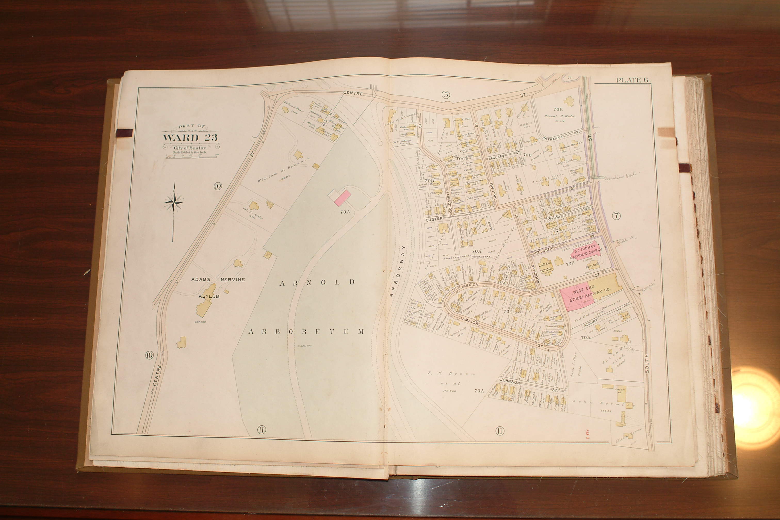
1896 G.W. Bromley Map of West Roxbury Photographed by Jamaica Plain Historical Society at City of Boston Archives
Byron Court / Chauncy Place / Columbus Avenue/ Ellsworth Place / Forest Hills Street / Glen Road / Iffley Road / Montebello Road / Olmstead Street / Park Lane Street / Peter Parley Street / Robeson Street / School Street / School Street Place / Sigourney Street / Sylvia Street / Walnut Avenue / Washington Street / Watson Place / Weld Avenue / Woodside Avenue
Alden Place / Amory Street / Arcadia Street / Argyle Street / Atherton Street / Baker Court / Beethoven Street / Bell Street / Bismarck Street / Boylston Place / Boylston Street / Brookside Avenue / Cable Street / Cedar Avenue / Chestnut Avenue / Chestnut Square / Clark Place / Copley Street / Cornwall Street / Dalrymple Street / Danforth Street / Egleston Street / Georgianna Street / Germania Street / Green Street / Helena Street / Jackson Place / Jess Street / Lamartine Court / Lamartine Place /Lamartine Square / Lamartine Street / Lawndale Terrace / Marbury Terrace / Marmion Street / Merriam Street / Minton Street / Oakdale Street / Ophir Street / Porter Street / School Street / Spring Lane / Vale Terrace / Wyman Street / Washington Street /
Adelaide Street / Adelaide Terrace / Boylston Street / Burr Street / Centre Street / Chestnut Avenue / Clive Street / Cranston Street / Danforth Street / Forbes Street / Lamartine Street / Nelson Street / Parker Court / Paul Gore Street / Paul Gore Terrace / Perkins Street / Rockview Street / Spring Lane / Sheridan Street / Wyman Street
Alfred Street / Centre Place / Centre Street / Chestnut Avenue / Enfield Street / Fessenden Street / Goldsmith Place / Green Street / Hazel Street / Jamaicaway / Lakeville Place / Lester Place / Lochstead Avenue / Maple Place / Myrtle Street / Robinwood Avenue / Parley Avenue / Pond Street / Rockview Street / Saint John Street / Starr Lane / Seaverns Avenue
Agassiz Park / Arborway / Brewer Street / Burroughs Street / Centre Street / Eliot Street / Hagar Street / Holbrook Street / May Street / Myrtle Street / Orchard Street / Park Place / Pond Street / Rugby Street / Thomas Street / Vane Street /
Arborway / Asbury Place /Atwood Square / Ballard Court / Ballard Street / Centre Street / Custer Street / Goldsmith Street / Hathaway Street / Jamaica Street / Johnson Street / Saint Joseph Street / South Street / Woodman Street
Alfred Street / Alveston Street / Bishop Street / Boynton Street / Brown Place / Call Street / Carolina Avenue / Centre Street / Child Street / Elm Street / Everett Street / Gordon Street / Green Street / Greenough Avenue / Greenough Place / Hall Street / Harris Avenue / John A Andrew Street / Keyes Street / Lee Street / Maple Place / Newbern Street / Revere Street / Roanoke Avenue / Rosemary Street / Seaverns Avenue / Sedgwick Street / South Street / Story Place
Burnett Street / Forest Hills Street / Garfield Avenue / Glenwood Avenue / Green Street / Glen Road / Keyes Street / Keyes Street Place / Lotus Place / Plainfield Street / Stedman Street / Union Avenue / Washington Street / Williams Street
Bynner Avenue / Castleton Street / Catalpa Street / Chestnut Street / Jamaicaway / Perkins Street / Pond Avenue / Pond Street / Prince Street / Willow Road Avenue / Zamora Street
Allandale Street / Avon Street / Centre Street / Green Hill Avenue / Louders Lane / May Street / Moss Hill Road / Mount Walley Avenue / Pond Street / Prince Street / Rockwood Street / Woodland Road
Anson Street / Barlow Street / Bussey Street / Cary Street / Centre Street / Forest Hills Avenue / Forest Hills Street / Hampstead Road / Hyde Park Avenue / Leland Street / Morton Street / Saint Mark Street / South Street / Spalding Street / Tower Street / Union Terrace / Wachusett Street / Walk Hill Street / Washington Street / Weld Hill Street / Woodlawn Street / Yale Street
Angell Street / Blue Hill Avenue / Calder Street / Canterbury Street / Forest Hills Street / Morton Street / Seaver Street / Sigourney Street / Walnut Street
1899 G.W. Bromley Map of West Roxbury Photographed by Jamaica Plain Historical Society at City of Boston Archives
Index Page
Plate 14
Arborway / Burroughs Street / Bynner Street / Castleton Street / Catalpa Street / Centre Street / Chestnut Street / Eliot Street / Jamaicaway / Lakeville Place / Lochstead Avenue / May Street / Myrtle Street / Orchard Street / Perkins Street / Pond Avenue / Pond Street / Prince Street / Rockwood Street /Willow Pond Road / Zamora Street /
Adelaide Street / Alden Place / Alfred Street / Alverston Street [Alveston] / Amory Street / Arcadia Street / Argyle Street / Atherton Street / Baker Court / Beethoven Street / Belmore Terrace / Biltmore Street / Bishop Street / Bismarck Street / Boylston Avenue/ Boylston Place / Boylston Street / Boylston Terrace / Brookside Avenue / Brown Place / Burr Street / Burroughs Street / Byron Court / Cable Street/ Calder Place / Cedar Avenue / Centre Place / Centre Street / Chauncey Place / Cheshire Street / Chestnut Avenue / Chestnut Court / Chestnut Place / Chestnut Square / Clark Place / Clive Street / Columbus Avenue / Copley Street / Cornwall Street / Cranston Street / Dalrymple Street / Danforth Street / Decher Avenue / Egleston Street / Elm Street / Ellsworth Place /Emsella Terrace/ Enfield Street / Erie Place / Everett Street / Fessenden Street / Forbes Street / Forest Hills Avenue / Garfield Avenue / Georgianna Street / Germania Street / Glade Avenue / Glen Road / Glenside Avenue / Goldsmith Place / Gordon Street / Green Street / Greenwood Avenue / Harris Avenue / Hazel Street / Helena Street / Iffley Road / Jackson Place / Jess Street / Lamartine Place / Lamartine Square / Lamartine Street / Lamartine Terrace /Lawndale Street / Lester Place / Locksley Avenue / Maple Place / Marbury Terrace / Marlow Terrace / Marmion Street / Merriam Street / Minton Street / Montebello Road / Myrtle Street / Nelson Terrace / Oakdale Street / Oakdale Terrace / Olmstead Street / Ophir Street / Park Lane Street / Parker Court / Park Place /Park Lane Street / Parley Avenue / Paul Gore Street / Peter Parley Street / Pond Street / Porter Street / Revere Street / Roanoke Avenue / Robeson Street / Robinwood Street / Rockview Street / St Johns Street / School Street / Seaverns Avenue / Sheridan Street / Sigourney Street / Spring Park Avenue / Starr Lane / Sylvia Street / Union Street / Walnut Avenue / Warren Square / Washington Street / Watson Place / Weld Avenue / Wheaton Square/ Woodside Street / Wyman Street
Blue Hill Avenue / Canterbury Street / Circuit Drive / Forest Hills Street / Glen Lane /Glen Road / Morton Street / Pierpont Road / Playstead Road / Seaver Street / Sigourney Street / Wachusetts Avenue / Walk Hill Street / Walnut Avenue
Allandale Street / Avon Street / Centre Street / Green Hill Avenue / Louders Lane / May Street / Moss Hill Road / Mount Walley Avenue / Pond Street / Rockwood Street / Weld Park / Woodland Road
1905 G.W. Bromley Map of West Roxbury Photographed by Jamaica Plain Historical Society at City of Boston Archives
Byron Court / Chauncy Place / Cleaves Street / Dixwell Street / Ellsworth Place / Eugene Street / Forest Hills Street / Glade Avenue / Glen Road / Glenside Avenue / Iffley Road / Montebello Road / Park Lane Street / Peter Parley Road / Robeson Street / School Street / Sigourney Street / Sylvia Street / Walnut Avenue / Washington Street / Weld Avenue / Woodside Avenue
Alden Place / Amory Street / Arcadia Street / Atherton Street / Baker Court / Beethoven Street / Biltmore Street / Bismarck Street / Boylston Place / Boylston Street / Brookside Avenue / Cable Street / Cedar Avenue / Cheshire Street / Chestnut Avenue / Chestnut Square / Chestnut Terrace / Clark Place / Copley Street / Cornwall Street / Dalrymple Street / Danforth Street / Egleston Street / Emsella Terrace / Georgiana Street / Germania Street / Green Street / Haverford Street / Helena Street / Hubbard Street / Lamartine Court / Lamartine Place / Lamartine Square / Lamartine Street / Lamartine Terrace / Lawndale Terrace / Marbury Terrace / Marmion Street / Merriam Street / Minton Street / Montebello Road / Oakdale Square / Oakdale Street / Ophir Street / Paul Gore Street / Porter Street / School Street / Washington Street / Wyman Street
Adelaide Street / Beecher Street / Belmore Terrace / Boylston Street / Burr Street / Centre Street / Chestnut Avenue / Chestnut Place / Clive Street / Cranston Street / Danforth Street / Day Street / Forbes Street / Hubbard Street / Lamartine Street / Oakview Terrace / Paul Gore Street / Parker Court / Perkins Street / Prout Street / Rockview Street / Sheridan Street / South Huntington Avenue / Spring Park Avenue / Wyman Street
Alfred Street / Beaufort Road / Calder Place / Centre Place / Centre Street / Chestnut Avenue / Chestnut Place / Enfield Street / Fessenden Street / Goldsmith Place / Green Street / Grovenor Road / Jamaicaway / Lakeville Place / Lester Place / Lochstead Avenue / Myrtle Street / Parley Avenue / Pond Street / Robinwood Avenue / Rockview Street / Spring Park Avenue / St John Street / Starr Lane / Warren Square
Agassiz Park / Aldworth Street / Arborway / Arborway Terrace / Brewer Street / Burroughs Street / Centre Street / Dane Street / Eliot Street / Hagar Street / Holbrook Street / May Street / Myrtle Street / Newsome Park / Orchard Street / Park Place / Pond Street / Prince Street / Thomas Street /
Achorn Circle / Arborway / Asbury Place / Ballard Place / Ballard Street / Centre Street / Custer Street / Goldsmith Street / Hathaway Street / Jamaica Place / Jamaica Street / Nathaniel Weld Place / Saint Joseph Street / Saint Rose Street / South Street / Woodman Street
Alfred Street / Alveston Street / Bishop Street / Boynton Street / Brown Place / Call Street / Carolina Avenue / Carolina Place / Centre Street / Child Street / Elm Street / Everett Street / Green Street / Greenough Avenue / Greenough Place / Gordon Street / Hall Street / Harris Avenue / John A Andrew Street / Keyes Street / Lee Street / Maple Place / Newbern Street / Revere Street / Roanoke Avenue / Rosemary Street / Seaverns Avenue / Sedgwick Street / South Street / Story Place / Williams Street
Brook Road / Burnett Street / Forest Hills Street / Glen Road / Green Street / Hale Street / Keyes Street / Jubes Street / Keyes Place / Lotus Street / Meehan Street / Plainfield Street / Stedman Street / Union Street / Washington Street / Williams Street /
Brookline Road / Bynner Street / Castleton Street / Chestnut Street / Jamaicaway / Prince Street / Perkins Street / Pond Avenue / Pond Street / South Huntington Avenue / Willow Pond Road / Zamora Street /
Allandale Street / Arborway / Avon Street / Centre Street / Green Hill Avenue / Louders Lane / May Street / Moss Hill Road / Mount Walley Avenue / Pond Street / Prince Street / Rockwood Street / Woodland Road
Anson Street / Arborway / Asticou Road / Barlow Street / Bussey Street / Cary Street / Centre Street / Forest Hills Avenue / Forest Hills Street / Hampstead Road / Hyde Park Avenue / Leland Street / Morton Street / Percy Street / Saint Mark Street / South Street / Spalding Street / Tower Street / Union Terrace / Varney Street / Wachusett Street / Walk Hill Street / Weld Hill Street / Woodlawn Street
Angell Street / Austin Street / Blue Hill Avenue / Calder Street / Canterbury Street / Forest Hills Street / Harvard Street / Morton Street / Seaver Street / Sigourney Street / Walk Hill Street / Walnut Avenue
1914 G.W. Bromley Map of West Roxbury Photographed by Jamaica Plain Historical Society at City of Boston Archives
Byron Court / Chauncy Place / Cleaves Street / Columbus Avenue / Dixwell Street / Ellsworth Street / Forest Hills Street / Glade Avenue / Glen Road / Glenside Avenue / Iffley Road / Montebello Road / Olmstead Street / Peter Parley Road / Robeson Street / School Street / Sigourney Street / Sylvia Street / Walnut Avenue / Washington Street / Weld Avenue / Woodside Avenue
Alden Place / Amory Street / Arcadia Street / Atherton Street / Baker Court / Beethoven Street / Biltmore Street / Bismarck Street / Boylston Place / Boylston Street / Brookside Avenue / Cable Street / Cardale Street / Cedar Avenue / Cheshire Street / Chestnut Avenue / Chestnut Square / Chestnut Terrace / Clark Place / Copley Street / Cornwall Street / Dalrymple Street / Danforth Street / Egleston Street / Emsella Terrace / Germania Street / Haverford Street / Helena Street / Hubbard Street / Jackson Place / Lamartine Court / Lamartine Place / Lamartine Street / Lamartine Square / Lamartine Terrace / Lawndale Terrace / Marbury Terrace / Marmion Street / Merriam Street /Minton Street / Montebello Road / Oakdale Square / Oakdale Street / Ophir Street / Paul Gore Street / Peabody Place / Porter Street / Washington Street / Wyman Street
Adelaide Street / Adelaide Terrace / Ashcroft Street / Beecher Street / Belmore Terrace / Boylston Street / Burr Street / Centre Street / Chestnut Avenue / Chestnut Place / Clive Street / Cranston Street / Danforth Street / Dresden Street / Forbes Street / Halifax Street / Hubbard Street / Kingsboro Park / Lamartine Street / Moraine Street / Oakview Terrace / Parker Court / Paul Gore Street / Perkins Street / Prout Street / Rock Hill Road Rockview Place // Saint Peters Street / Sheridan Street / South Huntington Avenue / Spring Park Avenue / Wyman Street
Alfred Street / Beaufort Road / Burrage Street / Calder Place / Centre Place / Centre Street / Chestnut Avenue / Chestnut Place / Enfield Street / Fessenden Street / Goldsmith Place / Goodrich Road / Green Street / Jamaicaway / Lakeville Place / Lester Place / Lochstead Avenue / Myrtle Street / Parley Vale / Pond Street / Robinwood Avenue / Rockview Street / Seaverns Avenue / Spring Park Avenue / St John Street / Starr Lane / Warren Square
Agassiz Park / Aldworth Street / Arborway / Arborway Court / Brewer Street / Burroughs Street / Centre Street / Dane Street / Dunster Road / Eliot Street / Hagar Street / Holbrook Street / May Street / Myrtle Street / Newsome Park / Orchard Street / Park PlacePond Street / Prince Street / Thomas Street /
Achorn Circle / Arborway / Atwood Square / Ballard Place / Ballard Street /Centre Street / Custer Street / Goldsmith Street / Hathaway Street / Jamaica Street / Nathaniel Weld Place / Saint Joseph Street / Saint Rose Street / South Street / Woodman Street
Alfred Street / Alveston Street / Bishop Street / Boynton Street / Brown Terrace / Call Street / Carolina Avenue / Carolina Place / Child Street / Crosby Square / Elm Street / Everett Street / Green Street / Greenough Avenue / Greenough Place / Gordon Street / Hall Street / Harris Avenue / Keyes Street / Lee Street / Maple Place / Newbern Street / Revere Street / Roanoke Avenue / Rosemary Street / Seaverns Avenue / Sedgwick Street / South Street / Storey Place / Verona Street / Williams Street /
Brook Road / Burnett Street / Forest Hills Street / Garfield Street / Glen Road / Green Street / Greenwood Avenue / Hale Street / Jubes Street / Keyes Street / Lotus Street / Meehan Street / Plainfield Street / Rossmore Road / Stedman Street / Union Avenue / Washington Street / Water Street / Williams Street /
Brookline Road / Bynner Street / Castleton Street / Chestnut Street / Halifax Street / Jamaicaway / Lochstead Avenue / Moraine Street / Parkview Road / Perkins Street / Pond Avenue / Pond Street / Pondview Avenue / Prince Street / South Huntington Avenue / Willow Pond Road / Zamora Street
Allandale Street / Arborway / Avon Street / Centre Street / Green Hill Avenue / Louders Lane / May Street / Moss Hill Road / Mount Walley Avenue / Perkins Street / Pond Street / Prince Street / Rockwood Street / Woodland Road
Anson Street / Arborway / Asticou Road / Barlow Street / Bussey Street / Cary Street / Centre Street / Chocorua Road / Craft Place / Forest Hills Street / Hampstead Road / Hillside Avenue / Hyde Park Avenue / Forest Hills Street / Forest Hills Avenue / Leland Street / Morton Street / Percy Street / Saint Ann Street / Saint Mark Street / South Street / Spalding Street / Tower Street / Union Terrace / Varney Street / Wachusett Street / Walk Hill Street / Washington Street / Weld Hill Street / Wenham Street / Woodlawn Street
Angell Street / Austin Street / Calder Street / Canterbury Street / Circuit Drive / Forest Hills Street / Loop Road / Morton Street / Pierpont Road / Playstead Road /
A number of institutions in the Boston area hold original fire insurance atlases including the Boston Public Library, David Rumsey Collection, Old Maps Online, Digital Commonwealth, Harvard Library, Remember Jamaica Plain , MIT Library, The Bostonian Society, The State Library of Massachusetts, Massachusetts Real Estate Atlas Digitization Project, City of Boston Archives and commercial providers such as Community Heritage Maps, Historic Map Works, and Ward Maps LLC.
The UC Berkeley library web site has an excellent article on Sanborn maps. Another good treatment of Sanborn maps can be found on Wikipedia.
Credits and Acknowledgements
Maps other than the 1858, 1884, and Digital Commonwealth maps appear here courtesy of the City of Boston Archive (with special thanks to Dave Nathan.) Melissa Gallagher Photography photographed the maps. Gretchen Grozier and Frank Norton provided production assistance. Charlie Rosenberg was the project manager.